Travel advisory · OmanSome governments advise against all but essential travel to Oman.Advice depends on your passport. Read your own government's advice before you book.Official advice
- Yemen border area · avoid all travel · Canada, Germany, France, Ireland, Italy, New Zealand, US
- Duqm · avoid non-essential travel · France, US
- Musandam · avoid non-essential travel · Germany, France, US
Also named by one government: Strait of Hormuz and other sensitive maritime areas (New Zealand), High seas of the Gulf of Aden and Arabian Sea (Ireland), Salalah (France)
| Government | Advice | Updated | Read the advice |
|---|---|---|---|
| United Kingdom (FCDO) | Regional tensions | – | Read the advice |
| United States (State Dept) | Reconsider travel | Oct 23, 2026 | Read the advice |
| Canada (Global Affairs) | Avoid non-essential travel | – | Read the advice |
| Germany (Auswärtiges Amt) | No advice against the whole country (regional advisories) | Oct 29, 2026 | Read the advice |
| New Zealand (SafeTravel) | Exercise increased caution (regional advisories) | – | Read the advice |
| Ireland (Department of Foreign Affairs) | High Degree of Caution (regional advisories) | – | Read the advice |
| France (Ministry for Europe and Foreign Affairs) | Increased caution across the whole country (zone de vigilance renforcée) (regional advisories) | – | Read the advice |
Checked daily from the governments' published advice; last checked Nov 2, 2026. RoamLedger summarises official advice; it is not advice from any government.

Hajar Mountains
The Hajar Mountains of northern Oman offer cooler air, plateau views and mountain villages, inland from the Gulf of Oman coast.
We may earn a commission. It never decides our picks.
The Hajar Mountains rise inland from the Gulf of Oman coast in northern Oman. Jebel Akhdar, whose name means green mountain, and Jebel Shams, one of the highest areas in the country, are the best-known high ground. Between the plateaus lie mountain villages, farms and wadis that cut deep canyons. The air is noticeably cooler than on the coast, which is a large part of why people make the trip.
Most trips are built around driving. Main roads reach the plateaus, but some tracks and wadi crossings need a four-wheel drive, and flash floods can rise quickly in wadis after rain, so check conditions before you enter a canyon. Nizwa, at the foot of the range, is a common base for its fort and market. Plan at least two or three days to link the plateau, the villages and a walk, and go between late autumn and spring.
Hajar Mountains in five
- Pick the mountain that fits your seasonThe ministry says the Hajar is milder than the lowlands, with Jebel Akhdar and Jebel Shams up to 15 degrees C cooler. Choose Jebel Akhdar for blossom and roses, Jebel Shams for canyon views.Best time for Jebel Akhdar
- Plan for a well-equipped 4x4FCDO says desert and mountain road trips can be dangerous unless you are in a well-equipped four-wheel drive. Ask your rental company about the roads you plan to use.UK travel advice
- Check the weather before any wadiFCDO warns that wadis can flash flood after heavy rain from October to March. Avoid them in rain and for at least one day afterward.UK travel advice
- Use Nizwa as the hubNizwa sits close to both big mountains, with a round fort, a souq and aflaj channels. A night there splits the driving between Jebel Akhdar and Jebel Shams.Nizwa and the Hajar
- Add the Eastern Hajar and the dunesThe ministry lists Wadi Bani Khalid in the Eastern Hajar, best from February to April, and the Sharqiya Sands nearby for a desert night.Sharqiya Sands
Neighborhoods
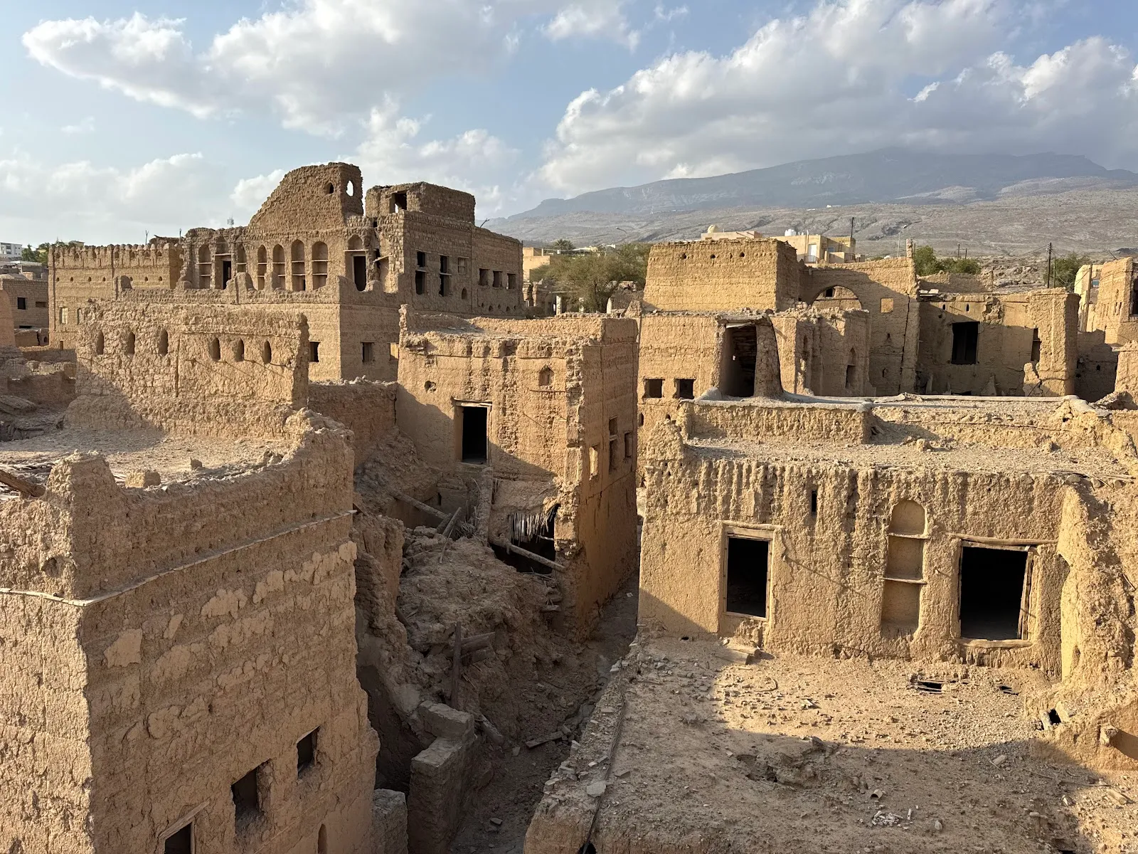
Al Hamra
- Best for: Hikers, drivers, viewpoints
- Price band: $$
- Old mud-brick houses in the upper village of Al Hamra
- Wadi Ghul viewpoints lie along the rim road
- Some tracks to the rim need a 4WD
Skip if you cannot drive mountain roads or join a tour.

Jebel Shams
Jebel Shams is Oman's highest mountain, and visitors come for rim walks above Wadi Ghul and air that runs cooler than the desert below.
Things to do in Hajar Mountains
See all attractions in Hajar Mountains



Need to know
- Airport
- Muscat (MCT), then about two hours' drive to the main peaks
- Getting there
- By road from Muscat or Nizwa
- Getting around
- Own 4x4 or a guided tour; check each road
- Best base
- Nizwa for both mountains; a plateau village for cool nights
- Time needed
- 3 to 5 days across the main stops
Weather by month
- Best
- Good
- Mixed
- JanuaryWarm, cold nights
- FebruaryWarm
- MarchWarm
- AprilHot
- MayVery hot
- JuneExtreme heat
- JulyExtreme heat
- AugustVery hot
- SeptemberVery hot
- OctoberHot
- NovemberWarm
- DecemberWarm, cold nights
Right now in Hajar Mountains
Local time, today's weather and the exchange rate, refreshed through the day.

22
- Feels like
- 21°
- Humidity
- 33%
- Wind
- 4 km/h
- Chance of rain
- 0%
Hajar Mountains
01:57 AM
Tuesday, November 3
- Today21°10°0%Tuesday: Partly cloudy. High 21°, Low 10°. Chance of rain 0%.
- Wed21°11°0%Wednesday: Cloudy. High 21°, Low 11°. Chance of rain 0%.
- Thu21°10°0%Thursday: Cloudy. High 21°, Low 10°. Chance of rain 0%.
- Fri20°10°0%Friday: Drizzle. High 20°, Low 10°. Chance of rain 0%.
- Sat20°11°0%Saturday: Clear. High 20°, Low 11°. Chance of rain 0%.
- Sun20°10°0%Sunday: Clear. High 20°, Low 10°. Chance of rain 0%.
Updated 12:08 AM local time · Powered by WeatherAPI.com · Weather data by Open-Meteo.com
Money
Mid-market rate1 USD = 0.3845 OMR
Rates from Nov 2, 2026 · Rates By Exchange Rate API
Before you go to Hajar Mountains
We may earn a commission. It never decides our picks.
Rules for Hajar Mountains, checked
- UK FCDO: road trips to the desert and mountains can be dangerous unless you are in a well-equipped four-wheel drive; take water and a phone.Checked Oct 4, 2026 · Source
- UK FCDO: wadis in Oman can flash flood after heavy rain from October to March; avoid them in rain and for at least one day after.Checked Oct 4, 2026 · Source
- Ministry of Heritage and Tourism: Wadi Bani Khalid, in the Eastern Hajar, lists February to April as its best time to visit.Checked Oct 4, 2026 · Source
Plan around Hajar Mountains
Terraces, roses and the plateau road
Read the guideJebel ShamsCanyon rims, climbing and the high peak
Read the guideAl HamraVillages, the Nakhur trail and Misfat
Read the guideJebel Akhdar or Jebel ShamsWhich mountain fits your trip
Read the guideNizwa and the HajarFort, souq and oasis hub
Read the guideSharqiya SandsA desert night east of the range
Read the guideAll of OmanRegions, entry basics and money
Read the guideHajar Mountains FAQ
What are the Hajar Mountains in Oman?
The range that runs through northern Oman, including the Western and Eastern Hajar. Jebel Akhdar, Jebel Shams, Wadi Bani Khalid and the Nizwa oasis towns all belong to it, with cooler air than the coast.
How many days do you need in the Hajar Mountains?
Three to five days covers Nizwa, one night on or near each big mountain and a village stop. Two days works if you choose only one mountain and skip the long loops.
Which is better, Jebel Akhdar or Jebel Shams?
Jebel Akhdar suits villages, terraces and spring blossom; Jebel Shams suits canyon edges and a high peak. The comparison post sets out who should choose which and how to combine them.
When is the best time to visit the Hajar Mountains?
Roughly November to March for comfortable weather, and March to May for blossom and rosewater at Jebel Akhdar. Summer is hot at the foot of the range, though the heights are cooler by up to 15 degrees C.
Is it safe to hike in the Hajar Mountains?
Follow marked trails, start early and carry water; FCDO notes that extreme heat has caused deaths in Oman. Avoid wadis in rain, tell someone your route and check that your insurance covers hiking.