Talassemtane National Park
Talassemtane National Park is in Morocco’s Rif region near Chefchaouen, with hiking, the Bridge of God and protected fir forests.
We may earn a commission. It never decides our picks.
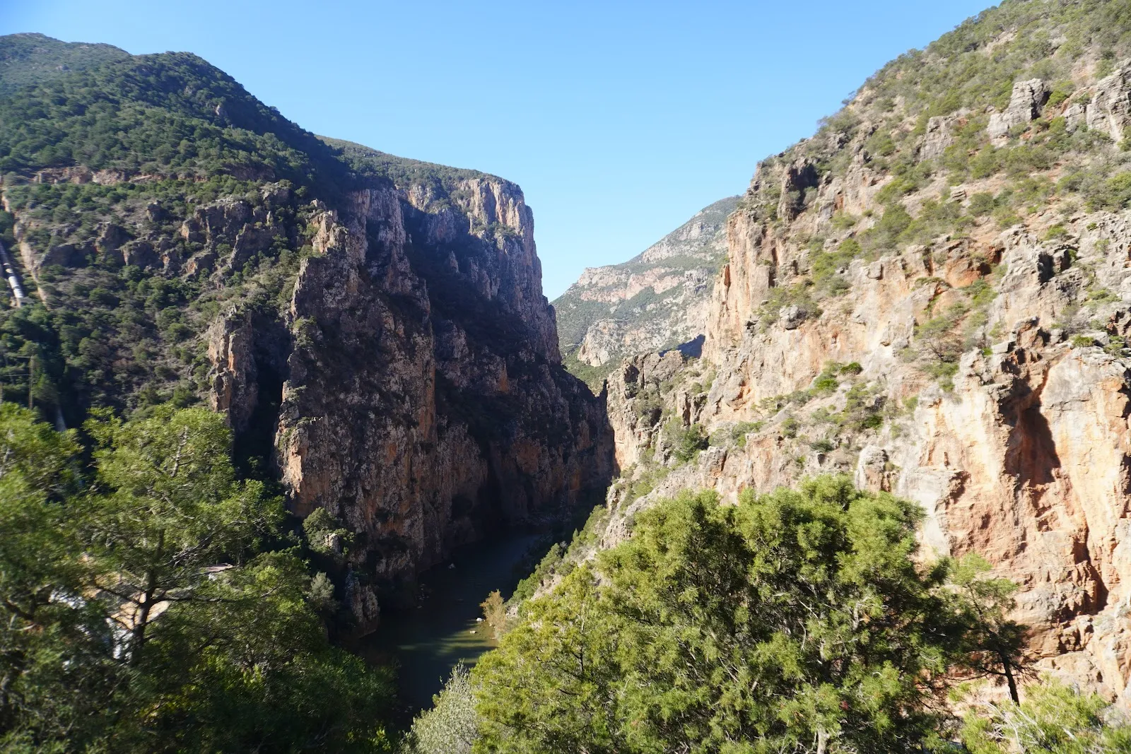
Talassemtane National Park is in Morocco’s Rif region, near Chefchaouen, and is a common hiking destination. Created in October 2004 to protect the country’s threatened fir forests, the park covers 589.5 km2. Its elevations range from 350 to 1,050 metres. The Bridge of God, a natural rock bridge, is one of its main attractions. The villages of El Kalaá and Akchour are also places to visit in the park.
Morocco’s only native Spanish firs grow in the park’s most strictly protected area. The park is also home to endangered Atlas cedar and Andalusian belladonna. More than 1,380 plant species have been recorded here, including 47 endemic to Morocco. Wildlife includes bearded vultures, Barbary macaques and Greek tortoises. More than 100 bird species live in the park, which is an Important Bird Area. Its location near Chefchaouen makes it a hiking option for travelers visiting the Rif.
Talassemtane National Park in five
- Start from Chefchaouen, not from a distanceThe tourist board places the park about ten kilometers from Chefchaouen. Use the town as your base and arrange a driver or guide for the trailhead rather than planning a self-drive loop.Chefchaouen
- Pick the waterfalls or the longer trekThe tourist board names the Akchour waterfalls as a hiker favorite, with God's Bridge, a natural arch in red rock above the Oued Farda, and the Cherafat waterfalls nearby. Longer routes need a guide.
- Hire a guide for anything off the main pathsThe UK government advises researching trails and hiring a professional guide when hiking in the Atlas, and the same logic applies in the Rif. Check what your insurance covers.Insurance
- Watch the rivers after rainThe UK government warns that heavy rain can cause flash flooding in mountains and near rivers in winter. Do not cross swollen streams, and turn back if the forecast turns.
- Check entrance and trail rules locallyThis guide has no verified fee, permit or trail-closure rule for the park. Ask your guesthouse or guide for the current position, and carry water and warm layers.
Things to do in Talassemtane National Park
See all attractions in Talassemtane National ParkNeed to know
- Entrance
- Not confirmed; ask your guide or guesthouse before you go
- Permits
- None confirmed in the sources checked; check locally
- Season
- Spring and autumn for walking; cold and wet in winter
- Nearest town
- Chefchaouen, about ten kilometers away
- Getting there
- Road from Chefchaouen; driver, taxi or guided transfer
Weather by month
- Rainy days
- Best
- Good
- Mixed
- JanuaryClear8 rainy daysHigh16°Low10°Cold, wetJanuaryClear
Mixed
- High
- 16°
- Low
- 10°
- Precipitation
- 67 mm
- Rainy days
- 8
- Snowy days
- 0
- Days with storms
- 0
Cold, wet
- FebruaryPartly cloudy9 rainy daysHigh16°Low10°Cold, wetFebruaryPartly cloudy
Mixed
- High
- 16°
- Low
- 10°
- Precipitation
- 68 mm
- Rainy days
- 9
- Snowy days
- 0
- Days with storms
- 0
Cold, wet
- MarchPartly cloudy12 rainy daysHigh17°Low11°ChangeableMarchPartly cloudy
Mixed
- High
- 17°
- Low
- 11°
- Precipitation
- 122 mm
- Rainy days
- 12
- Snowy days
- 0
- Days with storms
- 0
Changeable
- AprilPartly cloudy10 rainy daysHigh19°Low13°Mild, greenAprilPartly cloudy
Good
- High
- 19°
- Low
- 13°
- Precipitation
- 64 mm
- Rainy days
- 10
- Snowy days
- 0
- Days with storms
- 0
Mild, green
- MayClear5 rainy daysHigh22°Low15°Warm, easyMayClear
Best
- High
- 22°
- Low
- 15°
- Precipitation
- 29 mm
- Rainy days
- 5
- Snowy days
- 0
- Days with storms
- 0
Warm, easy
- JuneClear3 rainy daysHigh26°Low18°Warm, dryJuneClear
Best
- High
- 26°
- Low
- 18°
- Precipitation
- 11 mm
- Rainy days
- 3
- Snowy days
- 0
- Days with storms
- 0
Warm, dry
- JulyClear1 rainy dayHigh29°Low20°HotJulyClear
Best
- High
- 29°
- Low
- 20°
- Precipitation
- 2 mm
- Rainy days
- 1
- Snowy days
- 0
- Days with storms
- 0
Hot
- AugustClear3 rainy daysHigh29°Low21°HotAugustClear
Best
- High
- 29°
- Low
- 21°
- Precipitation
- 8 mm
- Rainy days
- 3
- Snowy days
- 0
- Days with storms
- 0
Hot
- SeptemberClear5 rainy daysHigh26°Low19°Warm, easySeptemberClear
Best
- High
- 26°
- Low
- 19°
- Precipitation
- 22 mm
- Rainy days
- 5
- Snowy days
- 0
- Days with storms
- 0
Warm, easy
- OctoberClear8 rainy daysHigh23°Low17°Mild, easyOctoberClear
Best
- High
- 23°
- Low
- 17°
- Precipitation
- 45 mm
- Rainy days
- 8
- Snowy days
- 0
- Days with storms
- 0
Mild, easy
- NovemberClear8 rainy daysHigh19°Low13°Wet spellsNovemberClear
Good
- High
- 19°
- Low
- 13°
- Precipitation
- 57 mm
- Rainy days
- 8
- Snowy days
- 0
- Days with storms
- 0
Wet spells
- DecemberPartly cloudy9 rainy daysHigh16°Low11°Cold, wetDecemberPartly cloudy
Mixed
- High
- 16°
- Low
- 11°
- Precipitation
- 72 mm
- Rainy days
- 9
- Snowy days
- 0
- Days with storms
- 0
Cold, wet
Average daily high and low in Talassemtane, 2016–2025. Rainy day: 1 mm of rain or more.
Right now in Talassemtane National Park
Local time, today's weather and the exchange rate, refreshed through the day.

11
- Feels like
- 10°
- Humidity
- 91%
- Wind
- 9 km/h
- Chance of rain
- 0%
Talassemtane National Park
10:38 PM
Monday, November 2
- Today18°12°0%Monday: Cloudy. High 18°, Low 12°. Chance of rain 0%.
- Tue13°10°75%Tuesday: Rain. High 13°, Low 10°. Chance of rain 75%.
- Wed11°10°88%Wednesday: Rain. High 11°, Low 10°. Chance of rain 88%.
- Thu13°9°23%Thursday: Cloudy. High 13°, Low 9°. Chance of rain 23%.
- Fri16°10°3%Friday: Cloudy. High 16°, Low 10°. Chance of rain 3%.
- Sat18°11°4%Saturday: Cloudy. High 18°, Low 11°. Chance of rain 4%.
- Sun18°13°40%Sunday: Cloudy. High 18°, Low 13°. Chance of rain 40%.
Updated 08:42 PM local time · Powered by WeatherAPI.com · Weather data by Open-Meteo.com
Money
Mid-market rate1 USD = 9.842 MAD
Rates from Nov 2, 2026 · Rates By Exchange Rate API
Day trips by train
- Chefchaouena short drive from the parkThe blue mountain town, the base for most park outings.Read the guide
- Tetouanabout 1 hr 40 min from ChefchaouenA UNESCO medina to the north-west, with museums and the Tamuda Bay coast.Read the guide
- Tangierabout 2 hr 14 min from ChefchaouenThe Strait city, a common start or end to a northern loop.Read the guide
Before you go to Talassemtane National Park
We may earn a commission. It never decides our picks.
Rules for Talassemtane National Park, checked
- Talassemtane: the tourist board places it about ten kilometers from Chefchaouen, over 60,000 hectares, with gorges, cliffs, caves and diverse forest.Checked Oct 2, 2026 · Source
- Mountain weather: heavy rain can cause flash flooding in mountains and near rivers in winter; walking and driving in flooded areas is dangerous.Checked Oct 2, 2026 · Source
Plan around Talassemtane National Park
The blue town and base for the park
Read the guideTetouan travel guideA UNESCO medina to the north-west
Read the guideTangier travel guideThe Strait city and Kasbah museums
Read the guideTangier to ChefchaouenBus, taxi, car or tour compared
Read the guideTazekka National ParkA cedar-forest park in the Middle Atlas
Read the guideAll of MoroccoCities, desert, coast and entry basics
Read the guideRif MountainsThe wider range around Chefchaouen
Read the guideTalassemtane National Park FAQ
Where is Talassemtane National Park?
In the Rif mountains near Chefchaouen. The tourist board puts it about ten kilometers from the town and gives its area as 60,000 hectares, with gorges, cliffs, caves and varied forest.
What is there to see in Talassemtane?
Waterfalls, gorges and forest trails. The tourist board names the Akchour waterfalls and God's Bridge, a natural arch above the Oued Farda, and the Cherafat waterfalls, and the park lists over 1,380 plant species.
Do you need a guide for Talassemtane?
For the main waterfall walks many visitors go without, but the UK government advises a professional guide for mountain hiking. For longer routes, hire one and check your insurance covers the activity.
Can you visit Talassemtane as a day trip from Chefchaouen?
Yes. A morning or day outing fits easily, as the park lies close to town. Arrange transport to the trailhead first, because this guide has no verified bus timetable.
When is the best time to hike Talassemtane?
Spring and early autumn are the easiest seasons. Winter brings rain, cold and flash floods near rivers, so choose the main waterfall routes only in dry weather, and check conditions with a guide first.