Travel advisory · MexicoSome governments advise against travel to parts of Mexico.The warnings cover only these areas: Colima, Guerrero, Sinaloa, Chiapas, Chihuahua, Federal Highway 199 San Cristóbal de las Casas–Palenque, Guanajuato, south of Highways 43D and 45D, Guatemala border region, Chiapas, Lagunas de Zempoala National Park, Michoacán, Nayarit, within 20 km of Sinaloa and Durango border, Nuevo León, except Monterrey, Piedras Negras, Route 85 Monterrey–Nuevo Laredo, Sonora, Tamaulipas, Tecate, Tijuana, US border region, Zacatecas.Advice depends on your passport. Read your own government's advice before you book.Official advice
- Colima · avoid all travel · Canada, Germany, France, UK
- Guerrero · avoid all travel · Canada, Germany, Spain, France, New Zealand, UK
- Sinaloa · avoid all travel · Canada, Germany, Spain, France, New Zealand, UK
- Chiapas · avoid non-essential travel · Canada, Spain, France
- Chihuahua · avoid non-essential travel · Canada, France, UK
- Federal Highway 199 San Cristóbal de las Casas–Palenque · avoid non-essential travel · France, UK
- Guanajuato, south of Highways 43D and 45D · avoid non-essential travel · Canada, New Zealand
- Guatemala border region, Chiapas · avoid non-essential travel · Germany, France, New Zealand
- Lagunas de Zempoala National Park · avoid non-essential travel · Canada, New Zealand
- Michoacán · avoid non-essential travel · Canada, Germany, New Zealand, UK
- Nayarit, within 20 km of Sinaloa and Durango border · avoid non-essential travel · Canada, New Zealand
- Nuevo León, except Monterrey · avoid non-essential travel · Canada, New Zealand
- Piedras Negras · avoid non-essential travel · Spain, France
- Route 85 Monterrey–Nuevo Laredo · avoid non-essential travel · Spain, France
- Sonora · avoid non-essential travel · Canada, New Zealand
- Tamaulipas · avoid non-essential travel · Canada, France, UK
- Tecate · avoid non-essential travel · France, UK
- Tijuana · avoid non-essential travel · France, UK
- US border region · avoid non-essential travel · Germany, Spain, France
- Zacatecas · avoid non-essential travel · Canada, Germany, Spain, France, UK
Also named by one government: Celaya–Irapuato–Salamanca triangle, Guanajuato (France), Culiacán and surrounding area (France), North of Ciudad Victoria, Tamaulipas (Germany), Route 129 Martinez de la Torre–Teziutlán (France), Route 131 Tapacoyan–Perote (France), Route 180 Martinez de la Torre–Papantla secondary roads (France), Route 40 Monterrey–Reynosa (France), Southern Michoacán from Uruapán to the coast (France), Acapulco (France), Baja California, except Tijuana and Tecate (France), Ciudad Acuña (Spain), Ciudad Juárez and surrounding area (Spain), Ciudad Obregón (France), Coahuila, except southern part (New Zealand), Coatzacoalcos (France), Colonias north and north-east of the Zócalo, Mexico City (France), Durango (France), East Nuevo León, bordering Tamaulipas (France), Guanajuato (Spain), Guanajuato, Highway 45 between León and Irapuato (New Zealand), Guanajuato, south-west of Highway 45D (UK), Jalisco, within 50 km of Michoacán border (Canada), Monclova (Spain), Morelos (France), Nayarit (France), Nogales (France), Non-tourist rural areas of Baja California (Spain), Non-tourist rural areas of Chihuahua (Spain), Non-tourist rural areas of Coahuila (Spain), Non-tourist rural areas of Durango (Spain), Non-tourist rural areas of Sonora (Spain), Northern municipalities of Jalisco (UK), Northern Tamaulipas from San Fernando to US border (Spain), Northern Veracruz bordering Tamaulipas (Spain), Northern Veracruz from Martinez de la Torre (France), Route 150D Puebla–Orizaba (France), Route 190 Oaxaca–Santo Domingo Tehuantepec (France), Route 85 and 83 Monterrey–Ciudad Victoria–Tampico (France), Route 95 Mexico City–Cuernavaca (France), Selva Lacandona (France), South and south-west of Lake Chapala, Jalisco (UK), South-west Jalisco and Los Altos, except Puerto Vallarta (France), South-west Michoacán (France), South-west Tamaulipas (France), Southern Guanajuato state (France), Southern Michoacán south of Morelia (Spain), Strip within 40 km of Guatemalan border, Chiapas (UK), Tepic (New Zealand), Toluca (France), Veracruz city (France)
| Government | Advice | Updated | Read the advice |
|---|---|---|---|
| United Kingdom (FCDO) | No advice against the whole country (regional advisories) | – | Read the advice |
| United States (State Dept) | Exercise increased caution | May 29, 2026 | Read the advice |
| Canada (Global Affairs) | Exercise a high degree of caution (regional advisories) | – | Read the advice |
| Germany (Auswärtiges Amt) | Besondere Vorsicht walten lassen (Sicherheitslage) (regional advisories) | Oct 19, 2026 | Read the advice |
| New Zealand (SafeTravel) | Exercise increased caution (regional advisories) | – | Read the advice |
| France (Ministry for Europe and Foreign Affairs) | Vigilance renforcée pour le reste du pays (regional advisories) | – | Read the advice |
Checked daily from the governments' published advice; last checked Nov 2, 2026. RoamLedger summarises official advice; it is not advice from any government.
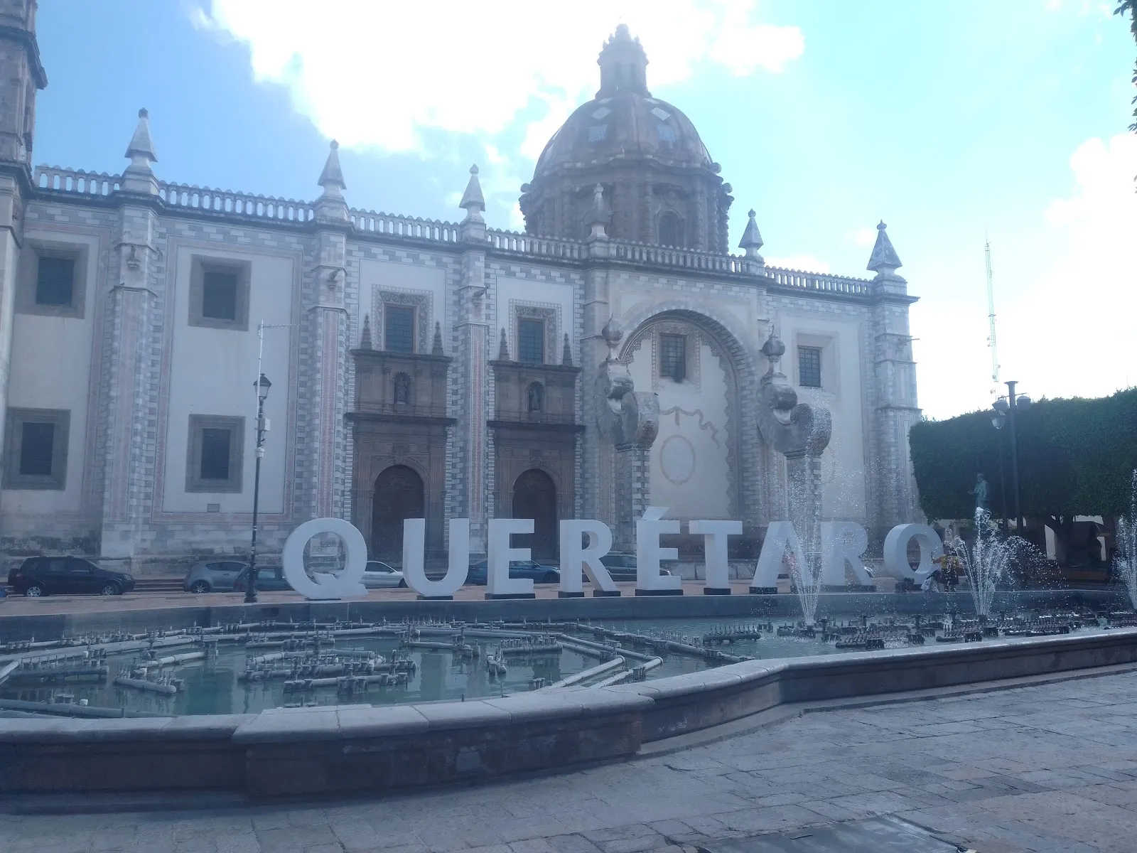
Querétaro
A colonial city in central Mexico with a UNESCO-listed historic center, an aqueduct built from 1726 to 1738, and vineyards nearby.
We may earn a commission. It never decides our picks.
Querétaro is the capital and largest city of Querétaro state, in central Mexico's Bajío region. It sits about 221 km northwest of Mexico City, at an average altitude of about 1,820 m. Spanish colonists founded the city on 25 July 1531. Its historic center, with Baroque churches, convents and a grid of streets, joined the UNESCO World Heritage list on 5 December 1996. Josefa Ortiz de Domínguez hosted the meetings where the 1810 conspiracy was planned, at what is now the Palacio de la Corregidora.
Stay in or near the Centro Histórico, where the Plaza de la Independencia, the Jardín Zenea and the museums in former monasteries are within walking distance. The aqueduct is the city's main symbol. Walk the center first, then add day trips: San Miguel de Allende is about 63 km away, and the Querétaro International Airport is about 16 km from the city. Winters can bring frost, and most rain falls in summer.
Querétaro in five
- Walk the historic center in a dayThe plazas, convents and balconied streets sit within a compact grid, and the center is largely walkable. Start early before the midday heat, then break for lunch.
- See the aqueduct at golden hourThe long stone arches on the city's east side are the landmark, best photographed late in the day when the light turns warm.
- Take a bus from Mexico CityCoaches from the capital reach Querétaro in about three hours or so, depending on traffic. Book first-class service and check which terminal you leave from.Mexico City
- Add wine and cheese countryVineyards and cheesemakers lie east of the city toward Tequisquiapan and Bernal. A guided tour or taxi saves the difficulty of driving after tastings.Northern Central Highlands
- Use it as a base for San MiguelSan Miguel de Allende is about an hour or more by road, and Querétaro's airport is the nearest large one. Many travelers sleep here the first night and move on.San Miguel de Allende
Things to do in Querétaro
See all attractions in Querétaro


Need to know
- Airport
- Querétaro (QRO), about 25 to 30 min from the center
- Getting there
- Coach from Mexico City in about 3 hours, or direct flights
- Getting around
- Walking in the center; taxis and ride apps beyond
- Best base
- The historic center near the main plazas
- Time needed
- 1 to 2 nights
Weather by month
- Rainy days
- Days with storms
- Best
- Good
- Mixed
- JanuaryClear1 rainy dayHigh23°Low8°Dry, cool nightsJanuaryClear
Best
- High
- 23°
- Low
- 8°
- Precipitation
- 4 mm
- Rainy days
- 1
- Snowy days
- 0
- Days with storms
- 0
Dry, cool nights
- FebruaryClear1 rainy dayHigh26°Low9°Dry, sunnyFebruaryClear
Best
- High
- 26°
- Low
- 9°
- Precipitation
- 7 mm
- Rainy days
- 1
- Snowy days
- 0
- Days with storms
- 0
Dry, sunny
- MarchClear2 rainy daysHigh28°Low11°Dry, warmMarchClear
Best
- High
- 28°
- Low
- 11°
- Precipitation
- 8 mm
- Rainy days
- 2
- Snowy days
- 0
- Days with storms
- 0
Dry, warm
- AprilClear2 rainy daysHigh30°Low13°Dry, hotAprilClear
Best
- High
- 30°
- Low
- 13°
- Precipitation
- 8 mm
- Rainy days
- 2
- Snowy days
- 0
- Days with storms
- 0
Dry, hot
- MayClear7 rainy daysHigh31°Low15°Hottest, pre-rainMayClear
Mixed
- High
- 31°
- Low
- 15°
- Precipitation
- 45 mm
- Rainy days
- 7
- Snowy days
- 0
- Days with storms
- 0
Hottest, pre-rain
- JuneRain13 rainy days1 day with stormsHigh28°Low15°Rainy afternoonsJuneRain
Mixed
- High
- 28°
- Low
- 15°
- Precipitation
- 132 mm
- Rainy days
- 13
- Snowy days
- 0
- Days with storms
- 1
Rainy afternoons
- JulyRain16 rainy days1 day with stormsHigh26°Low14°RainyJulyRain
Good
- High
- 26°
- Low
- 14°
- Precipitation
- 119 mm
- Rainy days
- 16
- Snowy days
- 0
- Days with storms
- 1
Rainy
- AugustRain14 rainy daysHigh26°Low14°RainyAugustRain
Good
- High
- 26°
- Low
- 14°
- Precipitation
- 109 mm
- Rainy days
- 14
- Snowy days
- 0
- Days with storms
- 0
Rainy
- SeptemberRain13 rainy daysHigh25°Low14°Rain, IndependenceSeptemberRain
Good
- High
- 25°
- Low
- 14°
- Precipitation
- 130 mm
- Rainy days
- 13
- Snowy days
- 0
- Days with storms
- 0
Rain, Independence
- OctoberClear6 rainy daysHigh25°Low12°Drier, clearOctoberClear
Best
- High
- 25°
- Low
- 12°
- Precipitation
- 36 mm
- Rainy days
- 6
- Snowy days
- 0
- Days with storms
- 0
Drier, clear
- NovemberClear2 rainy daysHigh24°Low10°Dry, mildNovemberClear
Best
- High
- 24°
- Low
- 10°
- Precipitation
- 12 mm
- Rainy days
- 2
- Snowy days
- 0
- Days with storms
- 0
Dry, mild
- DecemberClear2 rainy daysHigh23°Low9°Dry, posadasDecemberClear
Best
- High
- 23°
- Low
- 9°
- Precipitation
- 8 mm
- Rainy days
- 2
- Snowy days
- 0
- Days with storms
- 0
Dry, posadas
Average daily high and low in Querétaro, 2016–2025. Rainy day: 1 mm of rain or more.
Right now in Querétaro
Local time, today's weather and the exchange rate, refreshed through the day.

26
- Feels like
- 24°
- Humidity
- 33%
- Wind
- 4 km/h
- Chance of rain
- 0%
Querétaro
03:16 PM
Monday, November 2
- Today30°15°0%Monday: Cloudy. High 30°, Low 15°. Chance of rain 0%.
- Tue31°14°10%Tuesday: Drizzle. High 31°, Low 14°. Chance of rain 10%.
- Wed29°15°0%Wednesday: Cloudy. High 29°, Low 15°. Chance of rain 0%.
- Thu29°14°12%Thursday: Partly cloudy. High 29°, Low 14°. Chance of rain 12%.
- Fri29°16°16%Friday: Drizzle. High 29°, Low 16°. Chance of rain 16%.
- Sat25°14°30%Saturday: Drizzle. High 25°, Low 14°. Chance of rain 30%.
- Sun22°13°24%Sunday: Drizzle. High 22°, Low 13°. Chance of rain 24%.
Updated 12:11 PM local time · Powered by WeatherAPI.com · Weather data by Open-Meteo.com
Money
Mid-market rate1 USD = 18.81 MXN
Rates from Nov 2, 2026 · Rates By Exchange Rate API
Day trips by train
- San Miguel de Allendeabout 1 to 1.5 hours by roadA cobbled colonial town with a pink parish church.Read the guide
- Bernalabout 1 hour by roadA small town beneath a giant rock monolith, with a wine route nearby.
- Guanajuatoabout 2 to 2.5 hours by roadA long day trip or an overnight; check coach times.Read the guide
Before you go to Querétaro
We may earn a commission. It never decides our picks.
Rules for Querétaro, checked
- Many nationalities can enter Mexico without a visa, but many travelers still need an FMM tourist permit. Check current entry rules at gob.mx/sre before you book.Source
- Declare cash and goods above the customs allowance on the arrival form. Check the SAT customs rules before you carry large sums.
- The legal drinking age is 18, and bars and shops may ask for ID. Carry your passport or a photo ID when you go out.
- Tipping about 10 percent is usual at restaurants. Check the bill first, since some restaurants add a service charge.
- Dial 911 for police, fire or an ambulance.
Plan around Querétaro
Beaches, colonial cities, ruins and highlands
Read the guideSan Miguel de AllendeA colonial town an hour or more away
Read the guideGuanajuatoA colorful university city nearby
Read the guideNorthern Central HighlandsMore colonial towns and wine country
Read the guideAround Mexico CityShort trips from the capital
Read the guideQuerétaro FAQ
Is Querétaro worth visiting?
Yes for a UNESCO-listed center, an aqueduct and easy access to wine country and small towns. It is less touristy than San Miguel, so it suits travelers who like city atmosphere over postcard streets.
How many days do you need in Querétaro?
One night covers the center and the aqueduct. Two nights add a wine-country tour or Bernal, and more if you use it as a base for the Bajío.
How do you get from Mexico City to Querétaro?
By coach in about three hours, or by plane to the city's own airport. Coaches run frequently, so it is simple to leave for San Miguel the next morning.
Is Querétaro safe for tourists?
The historic center is busy and generally comfortable by day. Use ride apps or hotel taxis at night, watch your belongings, and check your government's current advice for the state.
Querétaro or San Miguel de Allende: which is better?
San Miguel for postcard streets, art and a tourist-friendly pace; Querétaro for a larger city feel, lower prices and wine-country access. Many trips include both.