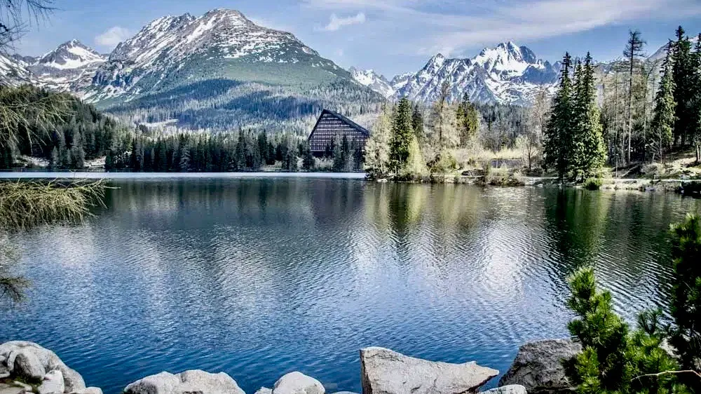
High Tatras
Plan a mountain trip in northern Slovakia for high peaks, glacial lakes and hiking routes in the country’s best-known range.
We may earn a commission. It never decides our picks.
The High Tatras are a mountain range in the Carpathians, on Slovakia’s northern border with Poland. Jagged peaks rise above forests, valleys and glacial lakes, and hiking trails lead into the mountains. Tatra National Park, Slovakia’s oldest national park, covers part of the range. Mountain settlements provide bases for trips into the hills. Plan a walking holiday, spend time in nature or combine mountain days with a stay in nearby towns.
Summer is the main hiking season. Winter brings snow and different mountain conditions. Allow several days if you want to take more than one hike, and longer for a slower pace or a mix of outdoor activities. Check current trail access and conditions before setting out, since weather and seasonal closures can affect routes. The High Tatras suit travelers looking for a mountain-focused trip who are ready to plan around the terrain.
High Tatras in five
- Stay on marked trailsIn Tatra National Park, follow marked hiking routes and obey seasonal closures. Check the park authority’s current notices before setting out.
- Check the mountain forecastConditions can change quickly at altitude. Check the Slovak Mountain Rescue Service forecast before a hike, then choose a route that fits the conditions.
- Use the Tatra Electric RailwayThe narrow-gauge Tatra Electric Railway connects Poprad-Tatry with Starý Smokovec, Štrbské Pleso and Tatranská Lomnica. Check current services before planning a connection.
- Carry euros and a payment cardSlovakia uses the euro. A card is useful for routine payments, but carry some cash for small purchases in mountain settlements.
- Pack layers and sturdy shoesEven a short walk from a resort can lead onto rocky, uneven paths. Bring shoes with grip and an extra layer for exposed sections.
Need to know
- Currency
- Euro (EUR)
- Entry
- Visa-free short stays for many passports Read more
- Emergency
- 112 emergency; 150 fire; 155 ambulance; 158 police
- Tipping
- Not expected; rounding up is common
- Time
- UTC+1; UTC+2 during daylight saving
Weather by month
- Best
- Good
- Mixed
- JanuaryCold, snow
- FebruaryCold, snow
- MarchSpring snow
- AprilUnsettled trails
- MayLate spring
- JuneSummer hikes
- JulyLong hiking days
- AugustPeak summer
- SeptemberEarly autumn
- OctoberAutumn chill
- NovemberSnow returns
- DecemberWinter sports
Right now in High Tatras
Local time, today's weather and the exchange rate, refreshed through the day.

0
- Feels like
- -2°
- Humidity
- 96%
- Wind
- 7 km/h
- Chance of rain
- 4%
High Tatras
09:37 PM
Monday, November 2
- Today1°-5°4%Monday: Cloudy. High 1°, Low -5°. Chance of rain 4%.
- Tue-2°-6°51%Tuesday: Drizzle. High -2°, Low -6°. Chance of rain 51%.
- Wed-2°-7°2%Wednesday: Drizzle. High -2°, Low -7°. Chance of rain 2%.
- Thu2°-7°0%Thursday: Fog. High 2°, Low -7°. Chance of rain 0%.
- Fri2°-4°0%Friday: Clear. High 2°, Low -4°. Chance of rain 0%.
- Sat4°-3°0%Saturday: Clear. High 4°, Low -3°. Chance of rain 0%.
- Sun4°-3°10%Sunday: Cloudy. High 4°, Low -3°. Chance of rain 10%.
Updated 08:53 PM local time · Powered by WeatherAPI.com · Weather data by Open-Meteo.com
Day trips by train
- Popradabout 30 min by trainUse the city as a transport hub or visit the historic center and its thermal water park.
- Spiš Castleabout 1 to 1.5 hours by carExplore the extensive medieval castle ruins above the Spiš region.
- Pieniny National Parkabout 1.5 to 2 hours by carTake in the Dunajec river gorge and the landscape around Červený Kláštor.
Before you go to High Tatras
Rules for High Tatras, checked
- Check the Schengen entry rules for your passport and trip with the European Commission before you travel.Source
- In Tatra National Park, stay on marked trails and follow posted closures and other restrictions.
- Check the Slovak Mountain Rescue Service’s current warnings before hiking in the High Tatras.
Plan around High Tatras
Transport options and practical details for planning journeys around Slovakia.
Read the guideVisas and entryEntry information and documents to check before travelling.
Read the guideWhere to stayCompare accommodation options for your trip.
Read the guideMoney and costsPlan payments and travel spending before you go.
Read the guideHigh Tatras FAQ
How many days do you need in the High Tatras?
Allow at least three days for a mountain walk, time in a resort such as Starý Smokovec or Tatranská Lomnica, and a change of plan if conditions close a route. Add days if you want longer hikes.
What is the best base in the High Tatras?
Starý Smokovec is a practical base for the Tatra Electric Railway and walks from the resort. Tatranská Lomnica and Štrbské Pleso are also connected by the railway; choose based on your planned routes and accommodation.
Can you visit the High Tatras without a car?
Yes. The Tatra Electric Railway links Poprad-Tatry with Starý Smokovec, Štrbské Pleso and Tatranská Lomnica. Check current services when arranging connections.
Do you need hiking boots in the High Tatras?
For mountain trails, wear sturdy shoes with good grip. Rocky, uneven paths can make ordinary city shoes a poor choice.
Is the High Tatras part of the Carpathian Mountains?
Yes. The High Tatras are a mountain range in the Carpathians, on the border between Slovakia and Poland.
What currency is used in the High Tatras?
The High Tatras are in Slovakia, which uses the euro (EUR).