Travel advisory · MalaysiaSome governments advise against travel to parts of Malaysia.The warnings cover only these areas: Eastern Sabah islands and dive sites, Malaysia–Thailand land border.Advice depends on your passport. Read your own government's advice before you book.Official advice
- Eastern Sabah islands and dive sites · avoid non-essential travel · Germany, New Zealand, UK
- Malaysia–Thailand land border · avoid non-essential travel · Germany, France, New Zealand
Also named by one government: Northern and eastern Sabah islands and surrounding waters (France), Sandakan (France), Semporna (France), Sulu Archipelago and intervening sea (Germany), Tawau (France), East coast of Sabah (Germany), North and east coasts of Sabah (France)
| Government | Advice | Updated | Read the advice |
|---|---|---|---|
| United Kingdom (FCDO) | No advice against the whole country (regional advisories) | – | Read the advice |
| United States (State Dept) | Level 1: Exercise Normal Precautions | Feb 22, 2026 | Read the advice |
| Canada (Global Affairs) | Take normal security precautions | – | Read the advice |
| Germany (Auswärtiges Amt) | No advice against the whole country (regional advisories) | Oct 16, 2026 | Read the advice |
| New Zealand (SafeTravel) | Exercise normal safety and security precautions overall (regional advisories) | – | Read the advice |
| France (Ministry for Europe and Foreign Affairs) | No advice against the whole country (regional advisories) | – | Read the advice |
Checked daily from the governments' published advice; last checked Nov 2, 2026. RoamLedger summarises official advice; it is not advice from any government.

Kota Kinabalu
Kota Kinabalu is Sabah's state capital on Borneo's northwest coast, and the base for island snorkeling, Tanjung Aru sunsets and trips to Mount Kinabalu, Malaysia's highest peak.
We may earn a commission. It never decides our picks.
Kota Kinabalu, often called KK, is the state capital of Sabah, on Borneo's northwest coast, facing the South China Sea. It is the main gateway to Sabah and Borneo, and the flight from Kuala Lumpur takes about three hours. About 500,000 people live on a narrow coastal plain between the Crocker Range and the sea. Many of the best-known spots are close to town: the islands of Tunku Abdul Rahman Park for snorkeling, the sunset at Tanjung Aru beach, and the views from Signal Hill.
The city suits a trip that mixes city and nature. Use it as a base for island day trips, or add Kinabalu Park, about 90 km away and roughly a two-hour drive, where Mount Kinabalu, Malaysia's highest peak, rises. The climate is tropical all year, with average temperatures of 26 to 28 °C. February and March are usually the driest months, and rain peaks around October. Plan two or three days for the city and islands, and one or two more for the mountain.
Kota Kinabalu in five
- Get into town from the airportKota Kinabalu International Airport (IATA: BKI) is about 7 km from the city. Taxis operate across the city, so the ride into town is short.Getting around
- Set up data before you landFree KK City WiFi, announced in 2017, gives each user 10GB a day, but the first phase covered only the Tun Fuad Stephens Road to Pantai Road area. Get an eSIM before you fly so you have maps outside that area.Phones and eSIM
- Plan Kinabalu Park as its own tripMount Kinabalu, Malaysia's highest peak, is in Kinabalu Park about 90 km from the city, roughly a two-hour drive. Give it a full day or more.Sabah
- Take the boat to Tunku Abdul Rahman Park from Jesselton PointBoats for the park islands of Gaya, Sapi, Manukan, Sulug and Mamutik leave from the city ferry terminal at Jesselton Point. Gaya is the largest of them and has about 8,000 residents, so choose the island that fits your plan.
- Pack for heat, humidity and rainAverage temperatures are 26 to 28 °C all year, and annual rainfall is about 2,400 mm. The Northeast Monsoon runs from November to March, so bring a rain jacket and quick-dry clothes.Clothing
Things to do in Kota Kinabalu
See all attractions in Kota Kinabalu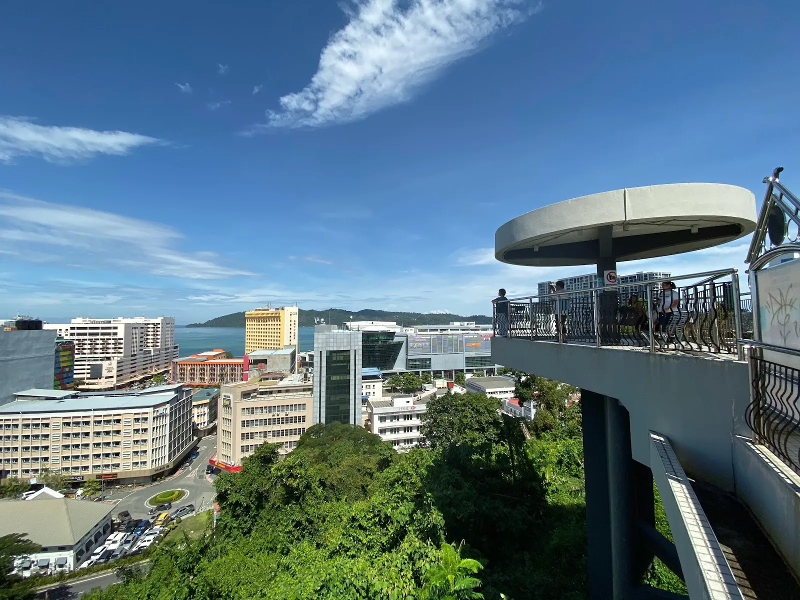




Need to know
- Currency
- Ringgit (MYR)
- Entry
- Entry rules depend on your passport; file the Malaysia Digital Arrival Card (MDAC) before you arrive Read more
- Emergency
- 999 police, fire and ambulance
- Tipping
- Not expected; some restaurants add a service charge
- Time
- UTC+8, no daylight saving
Weather by month
- Rainy days
- Best
- Good
- Mixed
- Poor
- JanuaryRain21 rainy daysHigh29°Low25°Wet, monsoonJanuaryRain
Mixed
- High
- 29°
- Low
- 25°
- Precipitation
- 273 mm
- Rainy days
- 21
- Snowy days
- 0
- Days with storms
- 0
Wet, monsoon
- FebruaryRain16 rainy daysHigh29°Low25°Driest monthFebruaryRain
Best
- High
- 29°
- Low
- 25°
- Precipitation
- 123 mm
- Rainy days
- 16
- Snowy days
- 0
- Days with storms
- 0
Driest month
- MarchRain20 rainy daysHigh29°Low25°Dry, warmMarchRain
Best
- High
- 29°
- Low
- 25°
- Precipitation
- 139 mm
- Rainy days
- 20
- Snowy days
- 0
- Days with storms
- 0
Dry, warm
- AprilRain20 rainy daysHigh30°Low26°Hot, humidAprilRain
Good
- High
- 30°
- Low
- 26°
- Precipitation
- 151 mm
- Rainy days
- 20
- Snowy days
- 0
- Days with storms
- 0
Hot, humid
- MayRain23 rainy daysHigh30°Low26°Hot, monsoon startsMayRain
Mixed
- High
- 30°
- Low
- 26°
- Precipitation
- 265 mm
- Rainy days
- 23
- Snowy days
- 0
- Days with storms
- 0
Hot, monsoon starts
- JuneRain21 rainy daysHigh30°Low26°Southwest monsoonJuneRain
Mixed
- High
- 30°
- Low
- 26°
- Precipitation
- 252 mm
- Rainy days
- 21
- Snowy days
- 0
- Days with storms
- 0
Southwest monsoon
- JulyRain20 rainy daysHigh30°Low26°Southwest monsoonJulyRain
Mixed
- High
- 30°
- Low
- 26°
- Precipitation
- 224 mm
- Rainy days
- 20
- Snowy days
- 0
- Days with storms
- 0
Southwest monsoon
- AugustRain21 rainy daysHigh30°Low26°Merdeka DayAugustRain
Good
- High
- 30°
- Low
- 26°
- Precipitation
- 245 mm
- Rainy days
- 21
- Snowy days
- 0
- Days with storms
- 0
Merdeka Day
- SeptemberRain23 rainy daysHigh29°Low25°Monsoon, easingSeptemberRain
Mixed
- High
- 29°
- Low
- 25°
- Precipitation
- 321 mm
- Rainy days
- 23
- Snowy days
- 0
- Days with storms
- 0
Monsoon, easing
- OctoberRain27 rainy daysHigh29°Low25°Rain peakOctoberRain
Poor
- High
- 29°
- Low
- 25°
- Precipitation
- 366 mm
- Rainy days
- 27
- Snowy days
- 0
- Days with storms
- 0
Rain peak
- NovemberRain25 rainy daysHigh29°Low25°Monsoon startsNovemberRain
Mixed
- High
- 29°
- Low
- 25°
- Precipitation
- 279 mm
- Rainy days
- 25
- Snowy days
- 0
- Days with storms
- 0
Monsoon starts
- DecemberRain26 rainy daysHigh29°Low25°F2 race, wet seasonDecemberRain
Mixed
- High
- 29°
- Low
- 25°
- Precipitation
- 315 mm
- Rainy days
- 26
- Snowy days
- 0
- Days with storms
- 0
F2 race, wet season
Average daily high and low in Kota Kinabalu, 2016–2025. Rainy day: 1 mm of rain or more.
Right now in Kota Kinabalu
Local time, today's weather and the exchange rate, refreshed through the day.

25
- Feels like
- 29°
- Humidity
- 87%
- Wind
- 4 km/h
- Chance of rain
- 100%
Kota Kinabalu
04:41 AM
Tuesday, November 3
- Today30°23°100%Tuesday: Rain. High 30°, Low 23°. Chance of rain 100%.
- Wed31°23°100%Wednesday: Drizzle. High 31°, Low 23°. Chance of rain 100%.
- Thu31°24°100%Thursday: Thunderstorms. High 31°, Low 24°. Chance of rain 100%.
- Fri31°24°100%Friday: Drizzle. High 31°, Low 24°. Chance of rain 100%.
- Sat31°23°100%Saturday: Rain. High 31°, Low 23°. Chance of rain 100%.
- Sun31°23°100%Sunday: Drizzle. High 31°, Low 23°. Chance of rain 100%.
Updated 01:50 AM local time · Weather data by Open-Meteo.com
Money
Mid-market rate1 USD = 4.057 MYR
Rates from Nov 2, 2026 · Rates By Exchange Rate API
Day trips by train
- Kinabalu Parkabout 90 km, roughly 2 hours by roadHome of Mount Kinabalu, Malaysia's highest peak, and the base for climbing it.Read the guide
- Lok Kawi Wildlife Parkabout 20 km south of the citySabah's first zoo, on a 280-acre site.Read the guide
- Tuaran Crocodile Farmabout 30 km north of the cityAround 1,400 crocodiles, the largest collection of its kind in Sabah.Read the guide
Before you go to Kota Kinabalu
Rules for Kota Kinabalu, checked
- Check entry rules for your passport on the Immigration Department of Malaysia site, and file the Malaysia Digital Arrival Card (MDAC) before you arrive.Source
- Cover shoulders and knees, and take off your shoes, when you enter mosques such as the Sabah State Mosque.
Plan around Kota Kinabalu
Regions, entry rules, transport and money for a Malaysia trip
Read the guideSabahThe state around Kota Kinabalu, with the parks and islands beyond the city
Read the guideGetting aroundFlights, buses, taxis and car hire for the city and the wider state
Read the guideWhere to stayHotels and guesthouses by neighborhood and budget
Read the guideMoney and costsTypical prices for a day in the city and on the islands
Read the guideVisas and entryEntry rules and the arrival card to file before you fly
Read the guideKota Kinabalu FAQ
Is Kota Kinabalu worth visiting?
Yes, if your trip includes Sabah. It is the main gateway to Sabah and Borneo, and to the islands, parks and rainforest reached from here. As a city alone it has few sights, so plan a day or two for it and spend the rest of the trip outside it.
How do you get to Kota Kinabalu?
Fly into Kota Kinabalu International Airport (BKI), about three hours from Kuala Lumpur. Malaysia Airlines, AirAsia and MASwings all have hubs there, and international flights serve Singapore, Hong Kong, Seoul and Perth, among other cities.
Is Kota Kinabalu far from the rest of Malaysia?
Yes. It is about 1,624 km from Kuala Lumpur and about 804 km from Kuching, so most trips start with a flight.
How do you get around Kota Kinabalu?
Scheduled buses run within the city and to other towns, minibuses and vans are also used, and taxis operate across the city. The Pan Borneo Highway links the city with Kudat, Sandakan and Tawau.
When is the best time to visit Kota Kinabalu?
February and March are usually the driest months, while rain peaks around October. April and May are the hottest months, and the Southwest Monsoon runs from May to September.
What language do people speak in Kota Kinabalu?
Malay is the main language, with a distinct Sabahan creole. Most residents speak English, especially younger people, and Hakka, Mandarin and Cantonese are widely spoken among Chinese residents.