Reykjanesfólkvangur Reserve
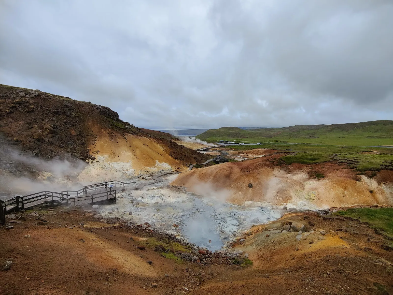
Reykjanesfólkvangur is a volcanic reserve on the Reykjanes Peninsula, a short drive from Reykjavík. Go for the steaming mud pots at Seltún, Lake Kleifarvatn and the seabird cliffs at Krýsuvíkurberg.
We may earn a commission. It never decides our picks.
Reykjanesfólkvangur is a nature reserve on the Reykjanes Peninsula in southwest Iceland, close to Reykjavík and Keflavík International Airport. Travelers reach it on a day trip from the capital or on the drive from the airport. Inside are the geothermal area at Seltún, Lake Kleifarvatn, the Krýsuvíkurberg bird cliff and ridge walks over lava fields.
The peninsula is volcanic, and eruptions have occurred there in recent years. Check official sources on volcanic status before you drive south, and follow road closures and warning signs. At Seltún, stay on the marked boardwalk: the mud pots and steam vents are hot, and the ground around them is unstable. This reserve suits people who want a half to full day of short walks close to the capital. Summer has the longest days. In winter, daylight is short and snow can cover the trails.
Reykjanesfólkvangur Reserve in five
- Check eruption and gas status firstVisit Reykjanes reports no ongoing eruption; the latest ended on 5 August 2025, the 12th since 2021. The Met Office said on 30 September 2026 that uplift continues at Svartsengi and a new eruption is the most likely scenario.Met Office update
- Stay on the Seltún boardwalkSeltún is a high-temperature geothermal area with mud pots and fumaroles. A boardwalk and walking paths lead through it, and parking sits by road 42 near Kleifarvatn.Seltún
- Never walk on new lavaThe UK government warns against walking on newly solidified lava because the crust can break without warning, and Safetravel says hiking on the lava is strictly forbidden even after an eruption stops.
- Look at Krýsuvíkurberg from the cliff topOn the coast is the largest bird cliff on the peninsula, with about 50,000 seabirds nesting. Keep well back from the edge, as the UK advice names cliff edges a common cause of accidents in Iceland.
- Walk Kleifarvatn or the ridgesKleifarvatn is the largest lake on the peninsula at about 10 km². The reserve's two main ridges, Sveifluháls and Núpshlíðarháls, rise 300 to 400 m; pick a path by weather and daylight.


Need to know
- Entrance
- Open reserve of about 300 km²; check each stop for parking rules
- Season
- Easiest in summer; autumn snow can reach the hills
- Nearest town
- Hafnarfjörður to the north; Grindavík to the south-west
- Getting there
- Road 42 south from the Reykjavík area to Seltún
- Check before going
- safetravel.is, vedur.is and visitreykjanes.is
Weather by month
- Rainy days
- Snowy days
- Best
- Good
- Mixed
- Poor
- JanuaryRain19 rainy days2 snowy daysHigh3°Low-1°Storms, short daysJanuaryRain
Poor
- High
- 3°
- Low
- -1°
- Precipitation
- 138 mm
- Rainy days
- 19
- Snowy days
- 2
- Days with storms
- 0
Storms, short days
- FebruaryRain19 rainy days3 snowy daysHigh4°Low0°Storms, iceFebruaryRain
Poor
- High
- 4°
- Low
- 0°
- Precipitation
- 141 mm
- Rainy days
- 19
- Snowy days
- 3
- Days with storms
- 0
Storms, ice
- MarchRain18 rainy days1 snowy dayHigh4°Low0°Ice, windMarchRain
Mixed
- High
- 4°
- Low
- 0°
- Precipitation
- 121 mm
- Rainy days
- 18
- Snowy days
- 1
- Days with storms
- 0
Ice, wind
- AprilRain17 rainy days1 snowy dayHigh6°Low3°Cool, quietAprilRain
Good
- High
- 6°
- Low
- 3°
- Precipitation
- 126 mm
- Rainy days
- 17
- Snowy days
- 1
- Days with storms
- 0
Cool, quiet
- MayRain17 rainy daysHigh8°Low5°Birds arriveMayRain
Good
- High
- 8°
- Low
- 5°
- Precipitation
- 126 mm
- Rainy days
- 17
- Snowy days
- 0
- Days with storms
- 0
Birds arrive
- JuneRain15 rainy daysHigh10°Low8°Long lightJuneRain
Best
- High
- 10°
- Low
- 8°
- Precipitation
- 97 mm
- Rainy days
- 15
- Snowy days
- 0
- Days with storms
- 0
Long light
- JulyRain15 rainy daysHigh12°Low10°Warmest, birdsJulyRain
Best
- High
- 12°
- Low
- 10°
- Precipitation
- 93 mm
- Rainy days
- 15
- Snowy days
- 0
- Days with storms
- 0
Warmest, birds
- AugustRain15 rainy daysHigh12°Low9°Warm, busyAugustRain
Best
- High
- 12°
- Low
- 9°
- Precipitation
- 111 mm
- Rainy days
- 15
- Snowy days
- 0
- Days with storms
- 0
Warm, busy
- SeptemberRain18 rainy daysHigh10°Low7°Fewer peopleSeptemberRain
Good
- High
- 10°
- Low
- 7°
- Precipitation
- 152 mm
- Rainy days
- 18
- Snowy days
- 0
- Days with storms
- 0
Fewer people
- OctoberRain18 rainy daysHigh8°Low5°Wet, windyOctoberRain
Mixed
- High
- 8°
- Low
- 5°
- Precipitation
- 147 mm
- Rainy days
- 18
- Snowy days
- 0
- Days with storms
- 0
Wet, windy
- NovemberRain16 rainy days1 snowy dayHigh6°Low2°Dark, windyNovemberRain
Poor
- High
- 6°
- Low
- 2°
- Precipitation
- 127 mm
- Rainy days
- 16
- Snowy days
- 1
- Days with storms
- 0
Dark, windy
- DecemberRain18 rainy days2 snowy daysHigh4°Low1°DarkestDecemberRain
Poor
- High
- 4°
- Low
- 1°
- Precipitation
- 125 mm
- Rainy days
- 18
- Snowy days
- 2
- Days with storms
- 0
Darkest
Average daily high and low in Seltún, 2016–2025. Rainy day: 1 mm of rain or more.
Right now in Reykjanesfólkvangur Reserve
Local time, today's weather and the exchange rate, refreshed through the day.

9
- Feels like
- 4°
- Humidity
- 89%
- Wind
- 48 km/h
- Chance of rain
- 100%
Reykjanesfólkvangur Reserve
08:48 PM
Monday, November 2
- Today8°7°100%Monday: Rain. High 8°, Low 7°. Chance of rain 100%.
- Tue8°3°100%Tuesday: Rain. High 8°, Low 3°. Chance of rain 100%.
- Wed6°3°18%Wednesday: Drizzle. High 6°, Low 3°. Chance of rain 18%.
- Thu7°3°89%Thursday: Rain. High 7°, Low 3°. Chance of rain 89%.
- Fri7°3°47%Friday: Drizzle. High 7°, Low 3°. Chance of rain 47%.
- Sat7°6°77%Saturday: Rain. High 7°, Low 6°. Chance of rain 77%.
- Sun6°-1°84%Sunday: Snow. High 6°, Low -1°. Chance of rain 84%.
Updated 08:10 PM local time · Powered by WeatherAPI.com · Weather data by Open-Meteo.com
Money
Mid-market rate1 USD = 121.8 ISK
Rates from Nov 2, 2026 · Rates By Exchange Rate API
What's on in Reykjanesfólkvangur Reserve
Concerts, festivals and big events in and around the city
Events calendarEvery year
- AugReykjavík PrideReykjavík, a day trip
Before you go to Reykjanesfólkvangur Reserve
We may earn a commission. It never decides our picks.
Rules for Reykjanesfólkvangur Reserve, checked
- Safetravel: hiking on the lava is strictly forbidden; stay on marked paths near Grindavík, where crevasses can be expected (page dated September 2025).Checked Oct 3, 2026 · Source
- UK advice: never walk on newly solidified lava; gas pollution can quickly exceed dangerous levels near an eruption site.Checked Oct 3, 2026 · Source
- Icelandic Met Office, 30 September 2026: slow uplift continues at Svartsengi; a magma intrusion that could lead to an eruption remains the most likely scenario.Checked Oct 3, 2026 · Source
Plan around Reykjanesfólkvangur Reserve
Volcanic safety and driving rules for the whole country
Read the guideSouthwest IcelandKeflavík, the Blue Lagoon and arrival-day plans
Read the guideReykjavíkBase city for day trips on the peninsula
Read the guideInsurance for IcelandCover for storms and rental car damage
Read the guideRenting a car abroadWind, sand and ash damage cover
Read the guideReykjanesfólkvangur Reserve FAQ
Is Reykjanesfólkvangur safe to visit with the volcanic activity?
Many visitors go, and Visit Reykjanes reports no ongoing eruption, but UK advice says further eruptions are likely. Check safetravel.is, vedur.is and visitreykjanes.is on the day, obey closures and stay on marked paths.
What is there to see at Seltún?
Mud pots, fumaroles and colored mineral deposits, reached by a boardwalk and walking paths next to road 42 and Lake Kleifarvatn. It is a short stop, so combine it with the lake or the coast.
How big is the Reykjanes nature reserve?
About 300 square kilometres, which Visit Reykjanes calls by far the largest reserve of its kind in Iceland. It borders the Bláfjöll reserve to the north and is crossed by two long ridges.
Can you hike to an eruption site?
Not onto active or fresh lava. Safetravel lists marked paths toward the older Fagradalsfjall eruption site in its September 2025 notes, but conditions change, so confirm the current status before you set out.
Do you need a car for the Reykjanes reserve?
Yes for independent visits, since stops sit along road 42 and side tracks. A guided geopark tour from the Reykjavík area is the alternative if you prefer not to drive near volcanic zones.