Travel advisory · MexicoSome governments advise against travel to parts of Mexico.The warnings cover only these areas: Colima, Guerrero, Sinaloa, Chiapas, Chihuahua, Federal Highway 199 San Cristóbal de las Casas–Palenque, Guanajuato, south of Highways 43D and 45D, Guatemala border region, Chiapas, Lagunas de Zempoala National Park, Michoacán, Nayarit, within 20 km of Sinaloa and Durango border, Nuevo León, except Monterrey, Piedras Negras, Route 85 Monterrey–Nuevo Laredo, Sonora, Tamaulipas, Tecate, Tijuana, US border region, Zacatecas.Advice depends on your passport. Read your own government's advice before you book.Official advice
- Colima · avoid all travel · Canada, Germany, France, UK
- Guerrero · avoid all travel · Canada, Germany, Spain, France, New Zealand, UK
- Sinaloa · avoid all travel · Canada, Germany, Spain, France, New Zealand, UK
- Chiapas · avoid non-essential travel · Canada, Spain, France
- Chihuahua · avoid non-essential travel · Canada, France, UK
- Federal Highway 199 San Cristóbal de las Casas–Palenque · avoid non-essential travel · France, UK
- Guanajuato, south of Highways 43D and 45D · avoid non-essential travel · Canada, New Zealand
- Guatemala border region, Chiapas · avoid non-essential travel · Germany, France, New Zealand
- Lagunas de Zempoala National Park · avoid non-essential travel · Canada, New Zealand
- Michoacán · avoid non-essential travel · Canada, Germany, New Zealand, UK
- Nayarit, within 20 km of Sinaloa and Durango border · avoid non-essential travel · Canada, New Zealand
- Nuevo León, except Monterrey · avoid non-essential travel · Canada, New Zealand
- Piedras Negras · avoid non-essential travel · Spain, France
- Route 85 Monterrey–Nuevo Laredo · avoid non-essential travel · Spain, France
- Sonora · avoid non-essential travel · Canada, New Zealand
- Tamaulipas · avoid non-essential travel · Canada, France, UK
- Tecate · avoid non-essential travel · France, UK
- Tijuana · avoid non-essential travel · France, UK
- US border region · avoid non-essential travel · Germany, Spain, France
- Zacatecas · avoid non-essential travel · Canada, Germany, Spain, France, UK
Also named by one government: Celaya–Irapuato–Salamanca triangle, Guanajuato (France), Culiacán and surrounding area (France), North of Ciudad Victoria, Tamaulipas (Germany), Route 129 Martinez de la Torre–Teziutlán (France), Route 131 Tapacoyan–Perote (France), Route 180 Martinez de la Torre–Papantla secondary roads (France), Route 40 Monterrey–Reynosa (France), Southern Michoacán from Uruapán to the coast (France), Acapulco (France), Baja California, except Tijuana and Tecate (France), Ciudad Acuña (Spain), Ciudad Juárez and surrounding area (Spain), Ciudad Obregón (France), Coahuila, except southern part (New Zealand), Coatzacoalcos (France), Colonias north and north-east of the Zócalo, Mexico City (France), Durango (France), East Nuevo León, bordering Tamaulipas (France), Guanajuato (Spain), Guanajuato, Highway 45 between León and Irapuato (New Zealand), Guanajuato, south-west of Highway 45D (UK), Jalisco, within 50 km of Michoacán border (Canada), Monclova (Spain), Morelos (France), Nayarit (France), Nogales (France), Non-tourist rural areas of Baja California (Spain), Non-tourist rural areas of Chihuahua (Spain), Non-tourist rural areas of Coahuila (Spain), Non-tourist rural areas of Durango (Spain), Non-tourist rural areas of Sonora (Spain), Northern municipalities of Jalisco (UK), Northern Tamaulipas from San Fernando to US border (Spain), Northern Veracruz bordering Tamaulipas (Spain), Northern Veracruz from Martinez de la Torre (France), Route 150D Puebla–Orizaba (France), Route 190 Oaxaca–Santo Domingo Tehuantepec (France), Route 85 and 83 Monterrey–Ciudad Victoria–Tampico (France), Route 95 Mexico City–Cuernavaca (France), Selva Lacandona (France), South and south-west of Lake Chapala, Jalisco (UK), South-west Jalisco and Los Altos, except Puerto Vallarta (France), South-west Michoacán (France), South-west Tamaulipas (France), Southern Guanajuato state (France), Southern Michoacán south of Morelia (Spain), Strip within 40 km of Guatemalan border, Chiapas (UK), Tepic (New Zealand), Toluca (France), Veracruz city (France)
| Government | Advice | Updated | Read the advice |
|---|---|---|---|
| United Kingdom (FCDO) | No advice against the whole country (regional advisories) | – | Read the advice |
| United States (State Dept) | Exercise increased caution | May 29, 2026 | Read the advice |
| Canada (Global Affairs) | Exercise a high degree of caution (regional advisories) | – | Read the advice |
| Germany (Auswärtiges Amt) | Besondere Vorsicht walten lassen (Sicherheitslage) (regional advisories) | Oct 19, 2026 | Read the advice |
| New Zealand (SafeTravel) | Exercise increased caution (regional advisories) | – | Read the advice |
| France (Ministry for Europe and Foreign Affairs) | Vigilance renforcée pour le reste du pays (regional advisories) | – | Read the advice |
Checked daily from the governments' published advice; last checked Nov 2, 2026. RoamLedger summarises official advice; it is not advice from any government.
Mulegé
A palm-lined river town in Baja California Sur, Mexico, on the Gulf of California, and a base for the Bahía Concepción beaches along Highway 1.
We may earn a commission. It never decides our picks.
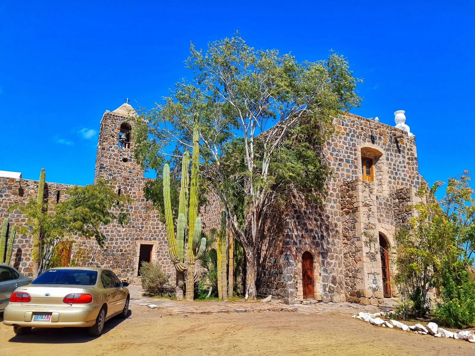
Mulegé is a small town on the Gulf of California coast of Baja California Sur, Mexico. The Mulegé River runs through it, and palms line its banks, so the town feels like a green break in Baja's desert. The mission of Santa Rosalía de Mulegé, founded by the Jesuits in 1705, stands on a hill above the town, and its grounds look down on the river and the palms. Bahía Concepción, a long bay with sandy beaches and quiet coves, is a short drive away.
Mulegé suits travelers driving Highway 1, the main road down the peninsula, who want a shaded stop, a place to swim and a base for paddling in the bay. Plan a night or two to cover the bay and the town. The cooler months, roughly November through April, are the most comfortable for being outdoors. Summer is very hot.
Mulegé in five
- Stay on Bahía Concepción for the beachesThe sheltered bay south of town has beaches popular for camping and kayaking. Bring water, shade and a bag for your trash, since services are few.
- Walk up to the missionThe Misión Santa Rosalía de Mulegé sits on a hill above the river, with views over the palms. The walk from the town center is short and best done in the morning.
- Book rock art visits aheadThe ancient rock art of the Sierra de San Francisco is protected, and visits are guided and arranged in advance. Ask in San Ignacio or Mulegé, and check access rules before you go.
- Fill up the tankTowns are far apart on Highway 1, and services thin out between them. Fill the tank when you can, carry water and avoid night driving.

Need to know
- Airport
- Loreto (LTO), about 2 hours south
- Getting there
- Highway 1 from Loreto (about 2 hours) or Santa Rosalía to the north
- Getting around
- On foot in town; a car for the bay and the highway
- Best base
- The town center, or camping on Bahía Concepción
- Time needed
- 1–2 nights
Weather by month
- Rainy days
- Days with storms
- Best
- Good
- Mixed
- Poor
- JanuaryClear1 rainy dayHigh22°Low12°Dry, coolJanuaryClear
Best
- High
- 22°
- Low
- 12°
- Precipitation
- 2 mm
- Rainy days
- 1
- Snowy days
- 0
- Days with storms
- 0
Dry, cool
- FebruaryClear1 rainy dayHigh23°Low13°Dry, coolFebruaryClear
Best
- High
- 23°
- Low
- 13°
- Precipitation
- 4 mm
- Rainy days
- 1
- Snowy days
- 0
- Days with storms
- 0
Dry, cool
- MarchClear1 rainy dayHigh26°Low15°Dry, mildMarchClear
Best
- High
- 26°
- Low
- 15°
- Precipitation
- 5 mm
- Rainy days
- 1
- Snowy days
- 0
- Days with storms
- 0
Dry, mild
- AprilClear0 rainy daysHigh29°Low17°Warm, dryAprilClear
Best
- High
- 29°
- Low
- 17°
- Precipitation
- 0 mm
- Rainy days
- 0
- Snowy days
- 0
- Days with storms
- 0
Warm, dry
- MayClear0 rainy daysHigh31°Low20°Hot, dryMayClear
Good
- High
- 31°
- Low
- 20°
- Precipitation
- 0 mm
- Rainy days
- 0
- Snowy days
- 0
- Days with storms
- 0
Hot, dry
- JuneClear0 rainy daysHigh35°Low25°Very hotJuneClear
Mixed
- High
- 35°
- Low
- 25°
- Precipitation
- 3 mm
- Rainy days
- 0
- Snowy days
- 0
- Days with storms
- 0
Very hot
- JulyClear3 rainy daysHigh36°Low28°Hottest monthJulyClear
Poor
- High
- 36°
- Low
- 28°
- Precipitation
- 8 mm
- Rainy days
- 3
- Snowy days
- 0
- Days with storms
- 0
Hottest month
- AugustClear6 rainy daysHigh36°Low28°Very hotAugustClear
Poor
- High
- 36°
- Low
- 28°
- Precipitation
- 24 mm
- Rainy days
- 6
- Snowy days
- 0
- Days with storms
- 0
Very hot
- SeptemberClear4 rainy days1 day with stormsHigh34°Low26°Hurricane riskSeptemberClear
Poor
- High
- 34°
- Low
- 26°
- Precipitation
- 68 mm
- Rainy days
- 4
- Snowy days
- 0
- Days with storms
- 1
Hurricane risk
- OctoberClear1 rainy dayHigh32°Low22°Hot, stormsOctoberClear
Mixed
- High
- 32°
- Low
- 22°
- Precipitation
- 12 mm
- Rainy days
- 1
- Snowy days
- 0
- Days with storms
- 0
Hot, storms
- NovemberClear1 rainy dayHigh27°Low17°Dry, pleasantNovemberClear
Best
- High
- 27°
- Low
- 17°
- Precipitation
- 8 mm
- Rainy days
- 1
- Snowy days
- 0
- Days with storms
- 0
Dry, pleasant
- DecemberClear2 rainy daysHigh23°Low14°Dry, coolDecemberClear
Best
- High
- 23°
- Low
- 14°
- Precipitation
- 8 mm
- Rainy days
- 2
- Snowy days
- 0
- Days with storms
- 0
Dry, cool
Average daily high and low in Mulegé, 2016–2025. Rainy day: 1 mm of rain or more.
Right now in Mulegé
Local time, today's weather and the exchange rate, refreshed through the day.

27
- Feels like
- 26°
- Humidity
- 55%
- Wind
- 23 km/h
- Chance of rain
- 2%
Mulegé
05:04 PM
Monday, November 2
- Today30°19°2%Monday: Clear. High 30°, Low 19°. Chance of rain 2%.
- Tue28°17°0%Tuesday: Clear. High 28°, Low 17°. Chance of rain 0%.
- Wed28°17°0%Wednesday: Cloudy. High 28°, Low 17°. Chance of rain 0%.
- Thu27°21°4%Thursday: Cloudy. High 27°, Low 21°. Chance of rain 4%.
- Fri27°21°13%Friday: Cloudy. High 27°, Low 21°. Chance of rain 13%.
- Sat26°22°3%Saturday: Cloudy. High 26°, Low 22°. Chance of rain 3%.
- Sun27°22°6%Sunday: Cloudy. High 27°, Low 22°. Chance of rain 6%.
Updated 03:32 PM local time · Weather data by Open-Meteo.com
Money
Mid-market rate1 USD = 18.81 MXN
Rates from Nov 2, 2026 · Rates By Exchange Rate API
Day trips by train
- Bahía Concepciónabout 15–45 min by carA long, sheltered bay of small beaches for camping and kayaking.
- Santa Rosalíaabout 1 hour by carA French-built mining town with a church designed by a famous engineer.
- San Ignacioabout 1.5 hours by carA date-palm oasis and base for the Sierra de San Francisco rock art.
Before you go to Mulegé
We may earn a commission. It never decides our picks.
Rules for Mulegé, checked
- Entry rules depend on your nationality. Check the FMM tourist permit issued on arrival at gob.mx/sre before you book.Source
- Declare cash above the legal limit on the customs form, and check the current amount with Mexican customs (SAT) before you travel.Source
- Dial 911 for police, fire or an ambulance anywhere in Mexico.
- Declare fresh fruit, vegetables and meat at Mexican customs, and check SENASICA's rules before you cross with food.Source
- Tipping waiters and taxi drivers is common; check the bill first, since some restaurants add a service charge.
Plan around Mulegé
Entry, money, safety and the regions on one page
Read the guideLoretoThe mission town and marine park to the south
Read the guideLa PazThe state capital at the end of the road
Read the guideBaja CaliforniaThe peninsula's northern half and the border
Read the guidePlan transport in MexicoDriving Highway 1 and renting a car
Read the guideMulegé FAQ
Is Mulegé worth visiting?
Yes as a stop on a Baja road trip, especially for the palm oasis, the mission and Bahía Concepción. It is small and quiet, so it suits one or two nights, not a long stay.
How do you get to Mulegé?
By car on Highway 1, about 2 hours from Loreto or 1 hour from Santa Rosalía. There is no regular public transport in the area, so most visitors rent a car or take a long-distance bus.
What is Bahía Concepción known for?
It is a sheltered bay of small beaches south of town, popular for camping, kayaking and fishing. Bring water and shade, and take your trash with you.
When is the best time to visit Mulegé?
November to April is dry and mild. Summer is very hot, and September and October bring hurricane and storm risk. Pick winter or early spring for camping and kayaking.
Can you visit the Sierra de San Francisco rock art from Mulegé?
Yes, but visits are guided and need arranging in advance, usually via San Ignacio. Check access and any permit rules before you plan a day or two for it.