Planifica un viaje
Idioma: Español
Planificador de viajesPlanifica tu viaje en un mapa

Destinos principales

EnglishDeutschFrançaisEspañolPortuguêsPortuguês (BR)Italiano
Aviso de viaje · MéxicoAlgunos gobiernos desaconsejan viajar a determinadas zonas de México.Las advertencias cubren únicamente estas zonas: Colima, Guerrero, Sinaloa, Chiapas, Chihuahua, Carretera federal 199 San Cristóbal de las Casas–Palenque, Guanajuato, al sur de las carreteras 43D y 45D, Región fronteriza con Guatemala, Chiapas, Parque nacional Lagunas de Zempoala, Michoacán, Nayarit, a menos de 20 km de la frontera con Sinaloa y Durango, Nuevo León, excepto Monterrey, Piedras Negras, Carretera 85 Monterrey–Nuevo Laredo, Sonora, Tamaulipas, Tecate, Tijuana, Región fronteriza con Estados Unidos, Zacatecas.Los consejos dependen de tu pasaporte. Lee los de tu propio gobierno antes de reservar.Recomendaciones oficiales
Zonas con advertencias
  • Colima · evitar todo viaje · Canadá, Alemania, Francia, Reino Unido
  • Guerrero · evitar todo viaje · Canadá, Alemania, España, Francia, Nueva Zelanda, Reino Unido
  • Sinaloa · evitar todo viaje · Canadá, Alemania, España, Francia, Nueva Zelanda, Reino Unido
  • Chiapas · evitar viajes no esenciales · Canadá, España, Francia
  • Chihuahua · evitar viajes no esenciales · Canadá, Francia, Reino Unido
  • Carretera federal 199 San Cristóbal de las Casas–Palenque · evitar viajes no esenciales · Francia, Reino Unido
  • Guanajuato, al sur de las carreteras 43D y 45D · evitar viajes no esenciales · Canadá, Nueva Zelanda
  • Región fronteriza con Guatemala, Chiapas · evitar viajes no esenciales · Alemania, Francia, Nueva Zelanda
  • Parque nacional Lagunas de Zempoala · evitar viajes no esenciales · Canadá, Nueva Zelanda
  • Michoacán · evitar viajes no esenciales · Canadá, Alemania, Nueva Zelanda, Reino Unido
  • Nayarit, a menos de 20 km de la frontera con Sinaloa y Durango · evitar viajes no esenciales · Canadá, Nueva Zelanda
  • Nuevo León, excepto Monterrey · evitar viajes no esenciales · Canadá, Nueva Zelanda
  • Piedras Negras · evitar viajes no esenciales · España, Francia
  • Carretera 85 Monterrey–Nuevo Laredo · evitar viajes no esenciales · España, Francia
  • Sonora · evitar viajes no esenciales · Canadá, Nueva Zelanda
  • Tamaulipas · evitar viajes no esenciales · Canadá, Francia, Reino Unido
  • Tecate · evitar viajes no esenciales · Francia, Reino Unido
  • Tijuana · evitar viajes no esenciales · Francia, Reino Unido
  • Región fronteriza con Estados Unidos · evitar viajes no esenciales · Alemania, España, Francia
  • Zacatecas · evitar viajes no esenciales · Canadá, Alemania, España, Francia, Reino Unido

También señalada por un gobierno: Triángulo Celaya–Irapuato–Salamanca, Guanajuato (Francia), Culiacán y alrededores (Francia), Norte de Ciudad Victoria, Tamaulipas (Alemania), Carretera 129 Martínez de la Torre–Teziutlán (Francia), Carretera 131 Tapacoyan–Perote (Francia), Carreteras secundarias de la 180 Martínez de la Torre–Papantla (Francia), Carretera 40 Monterrey–Reynosa (Francia), Sur de Michoacán, desde Uruapan hasta la costa (Francia), Acapulco (Francia), Baja California, excepto Tijuana y Tecate (Francia), Ciudad Acuña (España), Ciudad Juárez y alrededores (España), Ciudad Obregón (Francia), Coahuila, excepto el sur (Nueva Zelanda), Coatzacoalcos (Francia), Colonias al norte y noreste del Zócalo, Ciudad de México (Francia), Durango (Francia), Este de Nuevo León, limítrofe con Tamaulipas (Francia), Guanajuato (España), Guanajuato, carretera 45 entre León e Irapuato (Nueva Zelanda), Guanajuato, al suroeste de la carretera 45D (Reino Unido), Jalisco, a menos de 50 km de la frontera con Michoacán (Canadá), Monclova (España), Morelos (Francia), Nayarit (Francia), Nogales (Francia), Zonas rurales no turísticas de Baja California (España), Zonas rurales no turísticas de Chihuahua (España), Zonas rurales no turísticas de Coahuila (España), Zonas rurales no turísticas de Durango (España), Zonas rurales no turísticas de Sonora (España), Municipios del norte de Jalisco (Reino Unido), Norte de Tamaulipas, desde San Fernando hasta la frontera con EE. UU. (España), Norte de Veracruz, limítrofe con Tamaulipas (España), Norte de Veracruz desde Martínez de la Torre (Francia), Carretera 150D, Puebla–Orizaba (Francia), Carretera 190, Oaxaca–Santo Domingo Tehuantepec (Francia), Carreteras 85 y 83 Monterrey–Ciudad Victoria–Tampico (Francia), Carretera 95 Ciudad de México–Cuernavaca (Francia), Selva Lacandona (Francia), Sur y suroeste del lago de Chapala, Jalisco (Reino Unido), Suroeste de Jalisco y Los Altos, excepto Puerto Vallarta (Francia), Suroeste de Michoacán (Francia), Suroeste de Tamaulipas (Francia), Sur del estado de Guanajuato (Francia), Sur de Michoacán, al sur de Morelia (España), Franja de 40 km desde la frontera con Guatemala, Chiapas (Reino Unido), Tepic (Nueva Zelanda), Toluca (Francia), Ciudad de Veracruz (Francia)

GobiernoConsejosActualizadoLeer las recomendaciones
Reino Unido (FCDO)No advice against the whole country (regional advisories)–Leer las recomendaciones
Estados Unidos (Departamento de Estado)Exercise increased caution29 may 2026Leer las recomendaciones
Canadá (Asuntos Globales)Exercise a high degree of caution (regional advisories)–Leer las recomendaciones
Alemania (Auswärtiges Amt)Besondere Vorsicht walten lassen (Sicherheitslage) (regional advisories)19 oct 2026Leer las recomendaciones
Nueva Zelanda (SafeTravel)Exercise increased caution (regional advisories)–Leer las recomendaciones
Francia (Ministerio de Europa y Asuntos Exteriores)Vigilance renforcée pour le reste du pays (regional advisories)–Leer las recomendaciones

Revisado a diario según los consejos publicados por los gobiernos; última revisión 3 nov 2026.RoamLedger resume las recomendaciones oficiales; no son consejos de ningún gobierno.

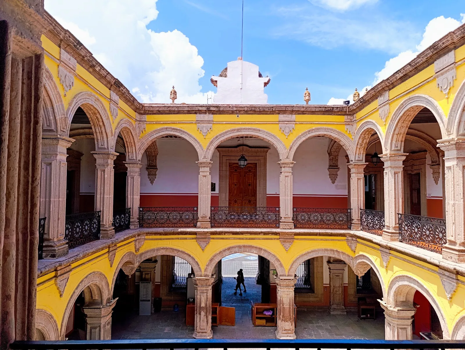
Catedral de Morelia
Iglesia

Catedral de Morelia

Morelia Cathedral stands on Avenida Madero in the historic center, next to the Plaza de Armas.

Morelia Cathedral stands on Avenida Madero in the historic center, next to the Plaza de Armas. Builders worked on it from 1660 to 1744, and the pink cantera stone facade is among the finest examples of Mexican Baroque. Its twin towers are visible from much of the old town. Inside are gilded altars, a large pipe organ and paintings by 18th-century artists. It is still a working church, so Mass is held here. The cathedral is lit after dark, and on Saturday evenings the streets around it fill with a light and fireworks show.

Built between 1660 and 1744
Catedral de Morelia
Catedral de Morelia

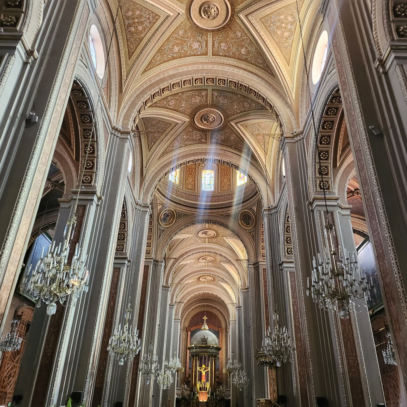
Construction of the cathedral began in 1660 and finished in 1744, a span of 84 years. That long timeline explains why the building mixes architectural styles. By the time it was completed it was one of the most important cathedrals in Mexico, and it remains one of the country's best examples of Spanish Baroque design.

The walls are made of cantera, a pink local stone. Over the centuries most of the surface has weathered to a softer pink, but some areas still show the stone's first, brighter color.

The towers and the facade
Catedral de Morelia
Catedral de Morelia

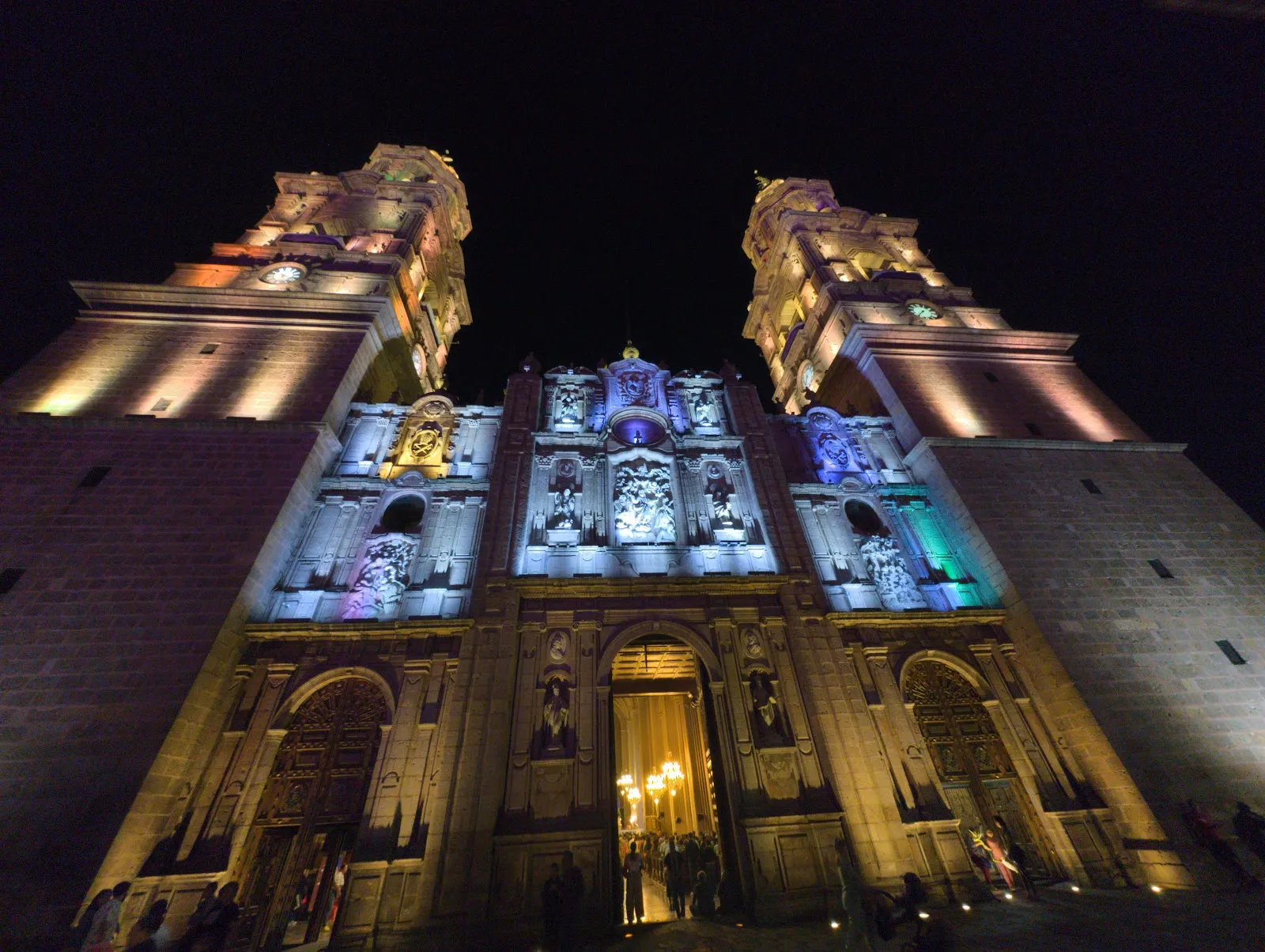
The twin towers are the cathedral's signature feature, and they rank among the tallest cathedral towers in Mexico. Each one shows the three phases of the long build. The bases follow a classical Herreresque style, the middle sections are baroque, and the tops are neoclassical, with many columns.

The cathedral runs along the side of the central plaza instead of facing it, and there is a plaza on each side. This gives you open space to step back and take in the full height of the front. The towers can be seen from far down the streets of the historic center.

Inside the cathedral

The interior has ornate, gilded altars and stained glass. A pipe organ, described as German and more than a century old, has around 4,600 pipes. The cathedral also holds paintings by 18th-century artists, among them Juan Rodríguez Juárez, José Maria de Ibarra and Miguel Cabrera.

You can attend Mass here, and there is an art museum connected to the cathedral. The building is kept clean and well maintained both inside and out.

After dark and on Saturday evenings

The cathedral is lit at night, and its carved stone details stand out against the dark sky. Every Saturday evening a light show with fireworks takes place at the cathedral. The street beside it is closed to traffic, and the area fills with people in their best clothes, vendors and families.

The cathedral is also a natural starting point for a tour of Morelia. The Plaza de Armas is right next to it, and guided walking tours of the center include it alongside other churches, squares and gardens.

Preguntas frecuentes

When was Morelia Cathedral built?

Work started in 1660 and ended in 1744, so it took 84 years. This is why the towers combine classical, baroque and neoclassical elements.

Is there a light show at the cathedral?

Yes. The cathedral is lit at night, and on Saturday evenings there is a light and fireworks show. The street beside it is closed to traffic then.

What is inside Morelia Cathedral?

There are gilded altars, stained glass, a pipe organ with about 4,600 pipes, and paintings by 18th-century artists such as Miguel Cabrera. An art museum is also linked to the cathedral.

Where is the cathedral?

It is on Avenida Francisco I. Madero Poniente in the historic center of Morelia, next to the Plaza de Armas.

Is the entrance wheelchair accessible?

Yes, the cathedral has a wheelchair accessible entrance and a wheelchair accessible parking lot. Restrooms are also available.
Más lugares imprescindibles en Morelia

Explorar todo