Reise planen
Sprache: Deutsch
ReiseplanerPlane deine Reise auf einer Karte

Top-Reiseziele

EnglishDeutschFrançaisEspañolPortuguêsPortuguês (BR)Italiano
Reisehinweis · MexikoEinige Regierungen raten von Reisen in Teile von Mexiko ab.Die Warnungen gelten nur für diese Gebiete: Colima, Guerrero, Sinaloa, Chiapas, Chihuahua, Bundesstraße 199 San Cristóbal de las Casas–Palenque, Guanajuato, südlich der Schnellstraßen 43D und 45D, Grenzgebiet zu Guatemala, Chiapas, Nationalpark Lagunas de Zempoala, Michoacán, Nayarit, innerhalb von 20 km zur Grenze zu Sinaloa und Durango, Nuevo León, außer Monterrey, Piedras Negras, Route 85 Monterrey–Nuevo Laredo, Sonora, Tamaulipas, Tecate, Tijuana, Grenzregion zu den USA, Zacatecas.Die Empfehlung hängt von Ihrem Reisepass ab. Lesen Sie vor der Buchung die Hinweise Ihrer eigenen Regierung.Offizielle Hinweise
Gebiete mit Warnungen
  • Colima · alle Reisen vermeiden · Kanada, Deutschland, Frankreich, Vereinigtes Königreich
  • Guerrero · alle Reisen vermeiden · Kanada, Deutschland, Spanien, Frankreich, Neuseeland, Vereinigtes Königreich
  • Sinaloa · alle Reisen vermeiden · Kanada, Deutschland, Spanien, Frankreich, Neuseeland, Vereinigtes Königreich
  • Chiapas · nicht notwendige Reisen vermeiden · Kanada, Spanien, Frankreich
  • Chihuahua · nicht notwendige Reisen vermeiden · Kanada, Frankreich, Vereinigtes Königreich
  • Bundesstraße 199 San Cristóbal de las Casas–Palenque · nicht notwendige Reisen vermeiden · Frankreich, Vereinigtes Königreich
  • Guanajuato, südlich der Schnellstraßen 43D und 45D · nicht notwendige Reisen vermeiden · Kanada, Neuseeland
  • Grenzgebiet zu Guatemala, Chiapas · nicht notwendige Reisen vermeiden · Deutschland, Frankreich, Neuseeland
  • Nationalpark Lagunas de Zempoala · nicht notwendige Reisen vermeiden · Kanada, Neuseeland
  • Michoacán · nicht notwendige Reisen vermeiden · Kanada, Deutschland, Neuseeland, Vereinigtes Königreich
  • Nayarit, innerhalb von 20 km zur Grenze zu Sinaloa und Durango · nicht notwendige Reisen vermeiden · Kanada, Neuseeland
  • Nuevo León, außer Monterrey · nicht notwendige Reisen vermeiden · Kanada, Neuseeland
  • Piedras Negras · nicht notwendige Reisen vermeiden · Spanien, Frankreich
  • Route 85 Monterrey–Nuevo Laredo · nicht notwendige Reisen vermeiden · Spanien, Frankreich
  • Sonora · nicht notwendige Reisen vermeiden · Kanada, Neuseeland
  • Tamaulipas · nicht notwendige Reisen vermeiden · Kanada, Frankreich, Vereinigtes Königreich
  • Tecate · nicht notwendige Reisen vermeiden · Frankreich, Vereinigtes Königreich
  • Tijuana · nicht notwendige Reisen vermeiden · Frankreich, Vereinigtes Königreich
  • Grenzregion zu den USA · nicht notwendige Reisen vermeiden · Deutschland, Spanien, Frankreich
  • Zacatecas · nicht notwendige Reisen vermeiden · Kanada, Deutschland, Spanien, Frankreich, Vereinigtes Königreich

Außerdem von einer Regierung genannt: Dreieck Celaya–Irapuato–Salamanca, Guanajuato (Frankreich), Culiacán und Umgebung (Frankreich), Norden von Ciudad Victoria, Tamaulipas (Deutschland), Straße 129 Martínez de la Torre–Teziutlán (Frankreich), Straße 131 Tapacoyan–Perote (Frankreich), Nebenstraßen der 180 Martínez de la Torre–Papantla (Frankreich), Straße 40 Monterrey–Reynosa (Frankreich), Süden von Michoacán, von Uruapan bis zur Küste (Frankreich), Acapulco (Frankreich), Baja California, außer Tijuana und Tecate (Frankreich), Ciudad Acuña (Spanien), Ciudad Juárez und Umgebung (Spanien), Ciudad Obregón (Frankreich), Coahuila, außer dem Süden (Neuseeland), Coatzacoalcos (Frankreich), Viertel nördlich und nordöstlich des Zócalo, Mexiko-Stadt (Frankreich), Durango (Frankreich), Osten von Nuevo León, an Tamaulipas grenzend (Frankreich), Guanajuato (Spanien), Guanajuato, Schnellstraße 45 zwischen León und Irapuato (Neuseeland), Guanajuato, südwestlich der Schnellstraße 45D (Vereinigtes Königreich), Jalisco, innerhalb von 50 km zur Grenze zu Michoacán (Kanada), Monclova (Spanien), Morelos (Frankreich), Nayarit (Frankreich), Nogales (Frankreich), Abgelegene ländliche Gebiete von Baja California (Spanien), Abgelegene ländliche Gebiete von Chihuahua (Spanien), Abgelegene ländliche Gebiete von Coahuila (Spanien), Abgelegene ländliche Gebiete von Durango (Spanien), Abgelegene ländliche Gebiete von Sonora (Spanien), Nördliche Gemeinden von Jalisco (Vereinigtes Königreich), Nördliches Tamaulipas, von San Fernando bis zur US-Grenze (Spanien), Nördliches Veracruz an der Grenze zu Tamaulipas (Spanien), Nördliches Veracruz ab Martínez de la Torre (Frankreich), Straße 150D, Puebla–Orizaba (Frankreich), Straße 190, Oaxaca–Santo Domingo Tehuantepec (Frankreich), Route 85 und 83 Monterrey–Ciudad Victoria–Tampico (Frankreich), Route 95 Mexiko-Stadt–Cuernavaca (Frankreich), Selva Lacandona (Frankreich), Süden und Südwesten des Chapala-Sees, Jalisco (Vereinigtes Königreich), Südwesten Jaliscos und Los Altos, außer Puerto Vallarta (Frankreich), Südwesten von Michoacán (Frankreich), Südwesten von Tamaulipas (Frankreich), Süden des Bundesstaates Guanajuato (Frankreich), Süden von Michoacán, südlich von Morelia (Spanien), Streifen bis 40 km von der guatemaltekischen Grenze, Chiapas (Vereinigtes Königreich), Tepic (Neuseeland), Toluca (Frankreich), Stadt Veracruz (Frankreich)

RegierungHinweiseAktualisiertHinweise lesen
Vereinigtes Königreich (FCDO)No advice against the whole country (regional advisories)–Hinweise lesen
Vereinigte Staaten (State Dept)Exercise increased caution29. Mai 2026Hinweise lesen
Kanada (Global Affairs)Exercise a high degree of caution (regional advisories)–Hinweise lesen
Deutschland (Auswärtiges Amt)Besondere Vorsicht walten lassen (Sicherheitslage) (regional advisories)19. Okt. 2026Hinweise lesen
Neuseeland (SafeTravel)Exercise increased caution (regional advisories)–Hinweise lesen
Frankreich (Ministerium für Europa und Auswärtige Angelegenheiten)Vigilance renforcée pour le reste du pays (regional advisories)–Hinweise lesen

Täglich anhand der veröffentlichten Hinweise der Regierungen geprüft; zuletzt geprüft am 3. Nov. 2026.RoamLedger fasst offizielle Hinweise zusammen; es handelt sich nicht um Empfehlungen einer Regierung.

Catedral de Morelia
Kirche

Catedral de Morelia

Morelia Cathedral stands on Avenida Madero in the historic center, next to the Plaza de Armas.

Morelia Cathedral stands on Avenida Madero in the historic center, next to the Plaza de Armas. Builders worked on it from 1660 to 1744, and the pink cantera stone facade is among the finest examples of Mexican Baroque. Its twin towers are visible from much of the old town. Inside are gilded altars, a large pipe organ and paintings by 18th-century artists. It is still a working church, so Mass is held here. The cathedral is lit after dark, and on Saturday evenings the streets around it fill with a light and fireworks show.

Built between 1660 and 1744
Catedral de Morelia
Catedral de Morelia

Construction of the cathedral began in 1660 and finished in 1744, a span of 84 years. That long timeline explains why the building mixes architectural styles. By the time it was completed it was one of the most important cathedrals in Mexico, and it remains one of the country's best examples of Spanish Baroque design.

The walls are made of cantera, a pink local stone. Over the centuries most of the surface has weathered to a softer pink, but some areas still show the stone's first, brighter color.

The towers and the facade
Catedral de Morelia
Catedral de Morelia

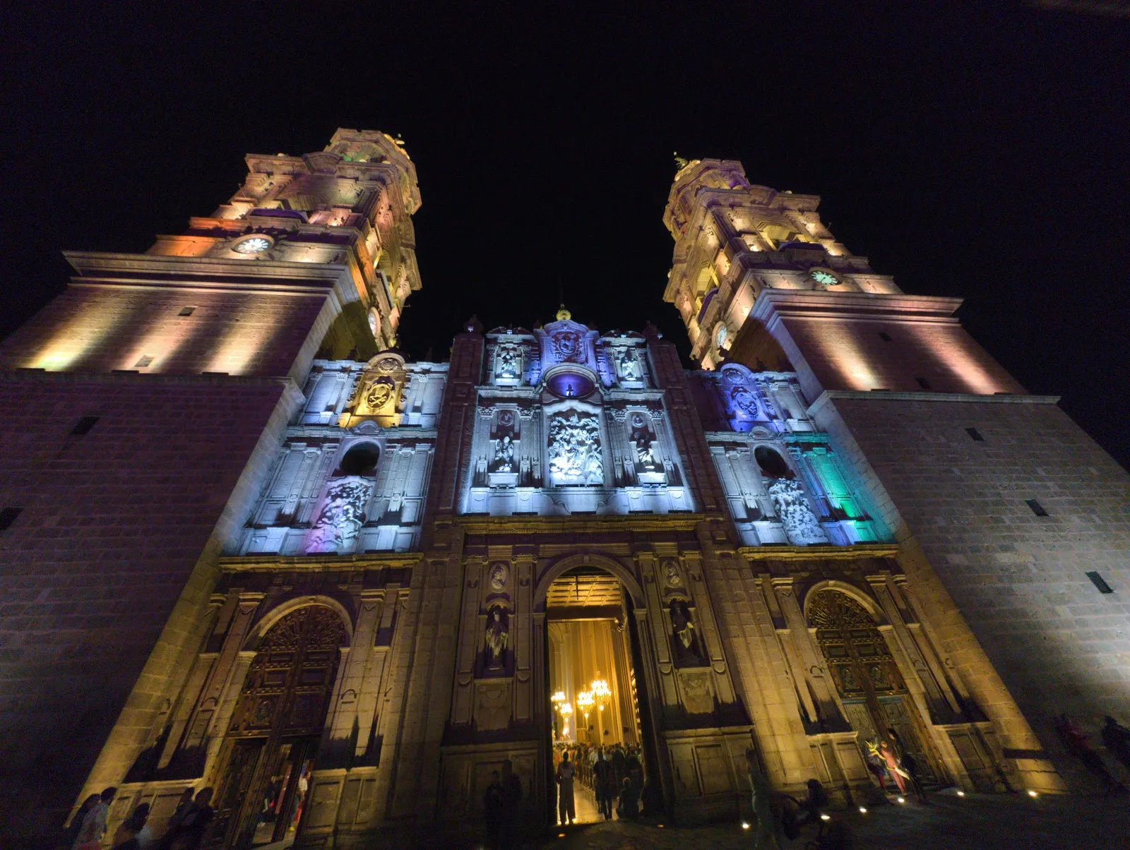
The twin towers are the cathedral's signature feature, and they rank among the tallest cathedral towers in Mexico. Each one shows the three phases of the long build. The bases follow a classical Herreresque style, the middle sections are baroque, and the tops are neoclassical, with many columns.

The cathedral runs along the side of the central plaza instead of facing it, and there is a plaza on each side. This gives you open space to step back and take in the full height of the front. The towers can be seen from far down the streets of the historic center.

Inside the cathedral

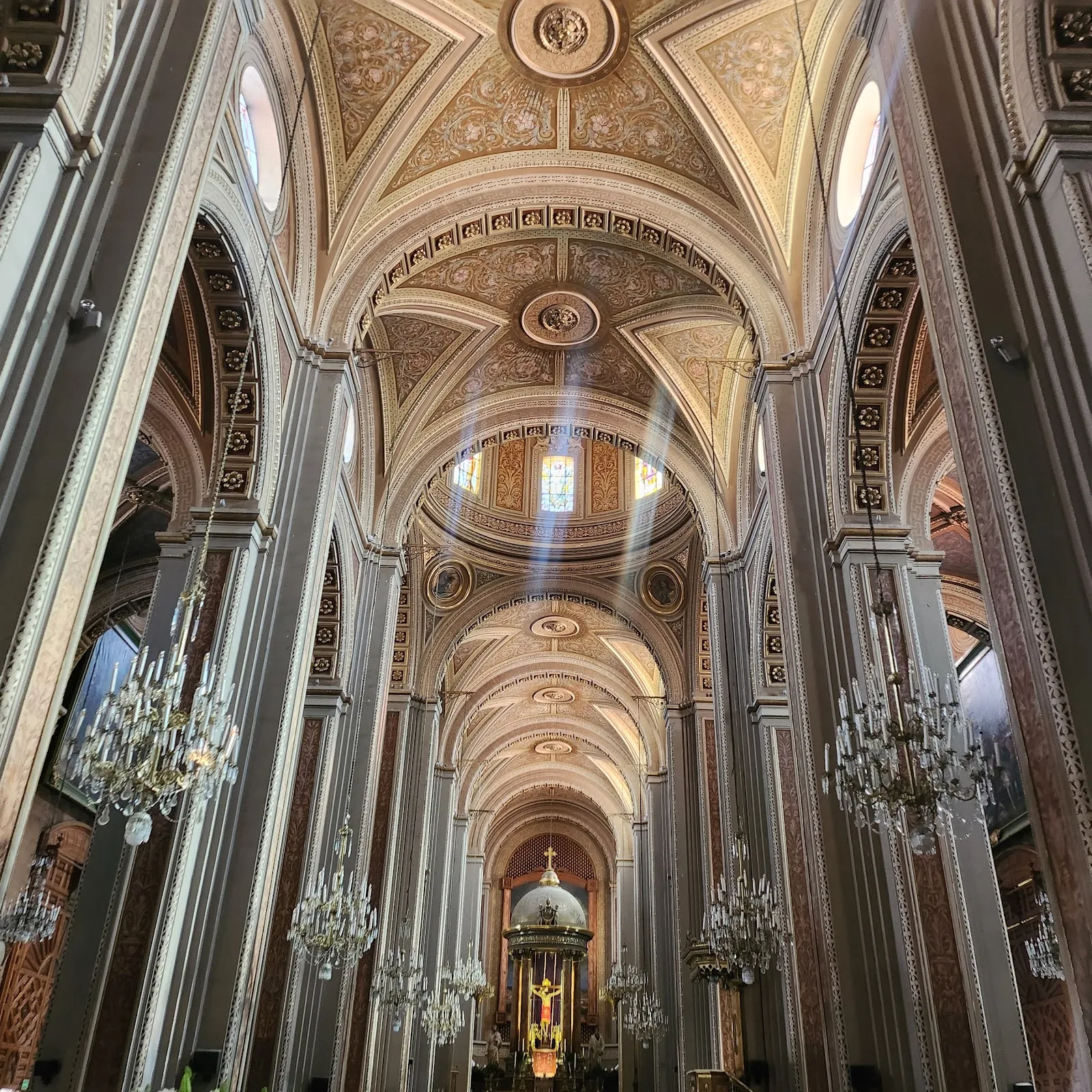
The interior has ornate, gilded altars and stained glass. A pipe organ, described as German and more than a century old, has around 4,600 pipes. The cathedral also holds paintings by 18th-century artists, among them Juan Rodríguez Juárez, José Maria de Ibarra and Miguel Cabrera.

You can attend Mass here, and there is an art museum connected to the cathedral. The building is kept clean and well maintained both inside and out.

After dark and on Saturday evenings

The cathedral is lit at night, and its carved stone details stand out against the dark sky. Every Saturday evening a light show with fireworks takes place at the cathedral. The street beside it is closed to traffic, and the area fills with people in their best clothes, vendors and families.

The cathedral is also a natural starting point for a tour of Morelia. The Plaza de Armas is right next to it, and guided walking tours of the center include it alongside other churches, squares and gardens.

Häufige Fragen

When was Morelia Cathedral built?

Work started in 1660 and ended in 1744, so it took 84 years. This is why the towers combine classical, baroque and neoclassical elements.

Is there a light show at the cathedral?

Yes. The cathedral is lit at night, and on Saturday evenings there is a light and fireworks show. The street beside it is closed to traffic then.

What is inside Morelia Cathedral?

There are gilded altars, stained glass, a pipe organ with about 4,600 pipes, and paintings by 18th-century artists such as Miguel Cabrera. An art museum is also linked to the cathedral.

Where is the cathedral?

It is on Avenida Francisco I. Madero Poniente in the historic center of Morelia, next to the Plaza de Armas.

Is the entrance wheelchair accessible?

Yes, the cathedral has a wheelchair accessible entrance and a wheelchair accessible parking lot. Restrooms are also available.
Weitere Highlights in Morelia

Alle entdecken