Reise planen
Sprache: Deutsch
ReiseplanerPlane deine Reise auf einer Karte

Top-Reiseziele

EnglishDeutschFrançaisEspañolPortuguêsPortuguês (BR)Italiano
Reisehinweis · MexikoEinige Regierungen raten von Reisen in Teile von Mexiko ab.Die Warnungen gelten nur für diese Gebiete: Colima, Guerrero, Sinaloa, Chiapas, Chihuahua, Bundesstraße 199 San Cristóbal de las Casas–Palenque, Guanajuato, südlich der Schnellstraßen 43D und 45D, Grenzgebiet zu Guatemala, Chiapas, Nationalpark Lagunas de Zempoala, Michoacán, Nayarit, innerhalb von 20 km zur Grenze zu Sinaloa und Durango, Nuevo León, außer Monterrey, Piedras Negras, Route 85 Monterrey–Nuevo Laredo, Sonora, Tamaulipas, Tecate, Tijuana, Grenzregion zu den USA, Zacatecas.Die Empfehlung hängt von Ihrem Reisepass ab. Lesen Sie vor der Buchung die Hinweise Ihrer eigenen Regierung.Offizielle Hinweise
Gebiete mit Warnungen
  • Colima · alle Reisen vermeiden · Kanada, Deutschland, Frankreich, Vereinigtes Königreich
  • Guerrero · alle Reisen vermeiden · Kanada, Deutschland, Spanien, Frankreich, Neuseeland, Vereinigtes Königreich
  • Sinaloa · alle Reisen vermeiden · Kanada, Deutschland, Spanien, Frankreich, Neuseeland, Vereinigtes Königreich
  • Chiapas · nicht notwendige Reisen vermeiden · Kanada, Spanien, Frankreich
  • Chihuahua · nicht notwendige Reisen vermeiden · Kanada, Frankreich, Vereinigtes Königreich
  • Bundesstraße 199 San Cristóbal de las Casas–Palenque · nicht notwendige Reisen vermeiden · Frankreich, Vereinigtes Königreich
  • Guanajuato, südlich der Schnellstraßen 43D und 45D · nicht notwendige Reisen vermeiden · Kanada, Neuseeland
  • Grenzgebiet zu Guatemala, Chiapas · nicht notwendige Reisen vermeiden · Deutschland, Frankreich, Neuseeland
  • Nationalpark Lagunas de Zempoala · nicht notwendige Reisen vermeiden · Kanada, Neuseeland
  • Michoacán · nicht notwendige Reisen vermeiden · Kanada, Deutschland, Neuseeland, Vereinigtes Königreich
  • Nayarit, innerhalb von 20 km zur Grenze zu Sinaloa und Durango · nicht notwendige Reisen vermeiden · Kanada, Neuseeland
  • Nuevo León, außer Monterrey · nicht notwendige Reisen vermeiden · Kanada, Neuseeland
  • Piedras Negras · nicht notwendige Reisen vermeiden · Spanien, Frankreich
  • Route 85 Monterrey–Nuevo Laredo · nicht notwendige Reisen vermeiden · Spanien, Frankreich
  • Sonora · nicht notwendige Reisen vermeiden · Kanada, Neuseeland
  • Tamaulipas · nicht notwendige Reisen vermeiden · Kanada, Frankreich, Vereinigtes Königreich
  • Tecate · nicht notwendige Reisen vermeiden · Frankreich, Vereinigtes Königreich
  • Tijuana · nicht notwendige Reisen vermeiden · Frankreich, Vereinigtes Königreich
  • Grenzregion zu den USA · nicht notwendige Reisen vermeiden · Deutschland, Spanien, Frankreich
  • Zacatecas · nicht notwendige Reisen vermeiden · Kanada, Deutschland, Spanien, Frankreich, Vereinigtes Königreich

Außerdem von einer Regierung genannt: Dreieck Celaya–Irapuato–Salamanca, Guanajuato (Frankreich), Culiacán und Umgebung (Frankreich), Norden von Ciudad Victoria, Tamaulipas (Deutschland), Straße 129 Martínez de la Torre–Teziutlán (Frankreich), Straße 131 Tapacoyan–Perote (Frankreich), Nebenstraßen der 180 Martínez de la Torre–Papantla (Frankreich), Straße 40 Monterrey–Reynosa (Frankreich), Süden von Michoacán, von Uruapan bis zur Küste (Frankreich), Acapulco (Frankreich), Baja California, außer Tijuana und Tecate (Frankreich), Ciudad Acuña (Spanien), Ciudad Juárez und Umgebung (Spanien), Ciudad Obregón (Frankreich), Coahuila, außer dem Süden (Neuseeland), Coatzacoalcos (Frankreich), Viertel nördlich und nordöstlich des Zócalo, Mexiko-Stadt (Frankreich), Durango (Frankreich), Osten von Nuevo León, an Tamaulipas grenzend (Frankreich), Guanajuato (Spanien), Guanajuato, Schnellstraße 45 zwischen León und Irapuato (Neuseeland), Guanajuato, südwestlich der Schnellstraße 45D (Vereinigtes Königreich), Jalisco, innerhalb von 50 km zur Grenze zu Michoacán (Kanada), Monclova (Spanien), Morelos (Frankreich), Nayarit (Frankreich), Nogales (Frankreich), Abgelegene ländliche Gebiete von Baja California (Spanien), Abgelegene ländliche Gebiete von Chihuahua (Spanien), Abgelegene ländliche Gebiete von Coahuila (Spanien), Abgelegene ländliche Gebiete von Durango (Spanien), Abgelegene ländliche Gebiete von Sonora (Spanien), Nördliche Gemeinden von Jalisco (Vereinigtes Königreich), Nördliches Tamaulipas, von San Fernando bis zur US-Grenze (Spanien), Nördliches Veracruz an der Grenze zu Tamaulipas (Spanien), Nördliches Veracruz ab Martínez de la Torre (Frankreich), Straße 150D, Puebla–Orizaba (Frankreich), Straße 190, Oaxaca–Santo Domingo Tehuantepec (Frankreich), Route 85 und 83 Monterrey–Ciudad Victoria–Tampico (Frankreich), Route 95 Mexiko-Stadt–Cuernavaca (Frankreich), Selva Lacandona (Frankreich), Süden und Südwesten des Chapala-Sees, Jalisco (Vereinigtes Königreich), Südwesten Jaliscos und Los Altos, außer Puerto Vallarta (Frankreich), Südwesten von Michoacán (Frankreich), Südwesten von Tamaulipas (Frankreich), Süden des Bundesstaates Guanajuato (Frankreich), Süden von Michoacán, südlich von Morelia (Spanien), Streifen bis 40 km von der guatemaltekischen Grenze, Chiapas (Vereinigtes Königreich), Tepic (Neuseeland), Toluca (Frankreich), Stadt Veracruz (Frankreich)

RegierungHinweiseAktualisiertHinweise lesen
Vereinigtes Königreich (FCDO)No advice against the whole country (regional advisories)–Hinweise lesen
Vereinigte Staaten (State Dept)Exercise increased caution29. Mai 2026Hinweise lesen
Kanada (Global Affairs)Exercise a high degree of caution (regional advisories)–Hinweise lesen
Deutschland (Auswärtiges Amt)Besondere Vorsicht walten lassen (Sicherheitslage) (regional advisories)19. Okt. 2026Hinweise lesen
Neuseeland (SafeTravel)Exercise increased caution (regional advisories)–Hinweise lesen
Frankreich (Ministerium für Europa und Auswärtige Angelegenheiten)Vigilance renforcée pour le reste du pays (regional advisories)–Hinweise lesen

Täglich anhand der veröffentlichten Hinweise der Regierungen geprüft; zuletzt geprüft am 2. Nov. 2026.RoamLedger fasst offizielle Hinweise zusammen; es handelt sich nicht um Empfehlungen einer Regierung.

The Diver
Wahrzeichen

The Diver

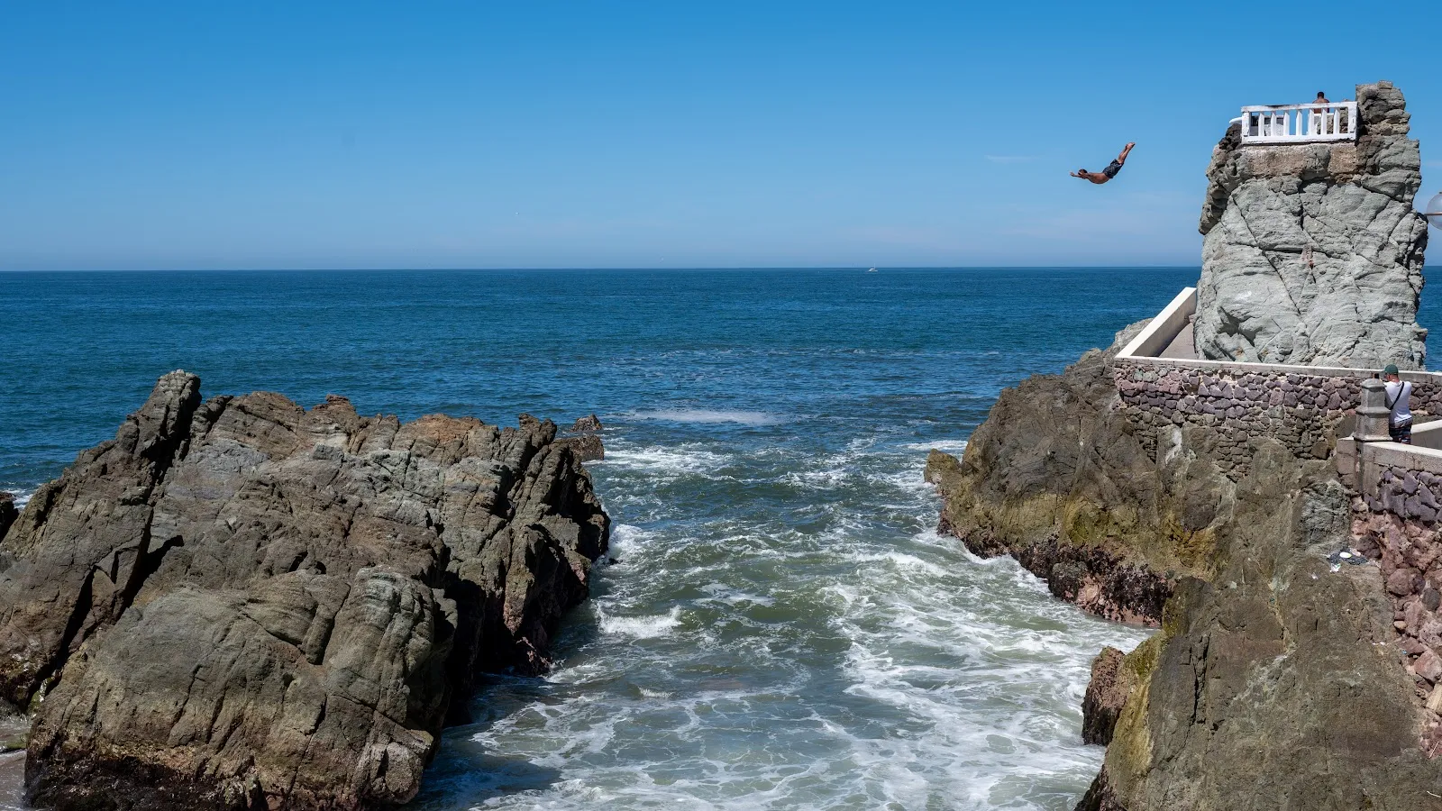
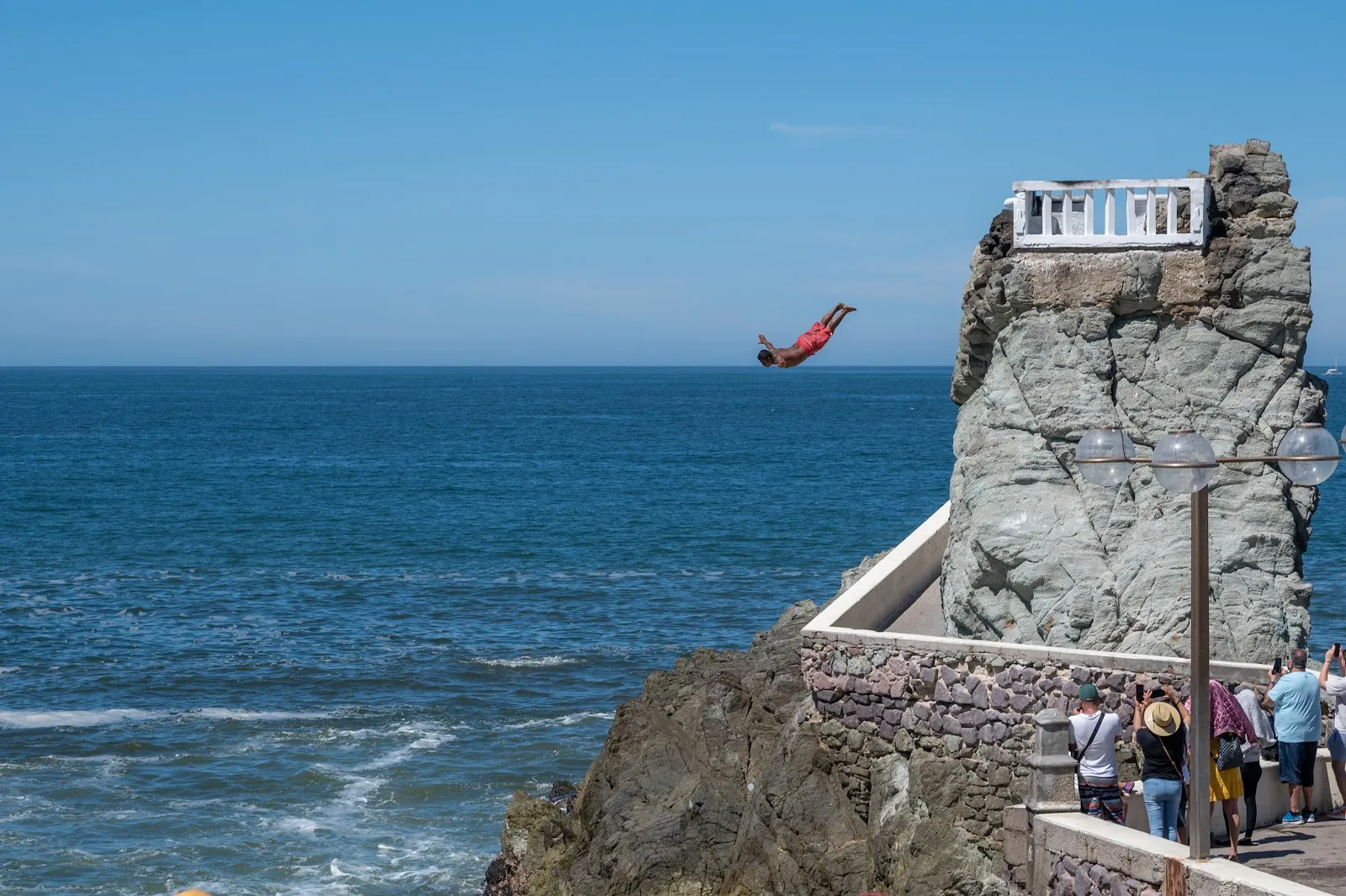
The Diver, known locally as El Clavadista, is a cliff-diving spot on the Malecón in Mazatlán.

The Diver, known locally as El Clavadista, is a cliff-diving spot on the Malecón in Mazatlán. A diver stands on a rocky platform marked by a white rail and drops head first into the Pacific, once the swell is large enough. The dives are performed daily, and sunset is the time most often recommended for watching. The divers are paid through donations, so bring some pesos. The old sea pools at the southern end of the Malecón are close by, which makes this an easy stop on a seafront walk.

What happens at El Clavadista

The Diver
The Diver

You will know the spot by the white rail on top of a rocky platform above the water. From the street it looks modest, but the drop is high, and the rock overhangs the sea below.

A diver climbs to the top and waits for the swell. When a wave is big enough, he dives head first into the water. The performance takes place daily, though the sea decides the timing, so allow a little time for the right wave.

The dive is dangerous, especially when the waves are large. Divers have died performing it at this location. Watch quietly, and remember that only the divers go off the rock. Spectators are not allowed to jump.

Donations and how the divers are paid
The Diver
The Diver

The divers work as a group. While one of them is on the rock, other members of the group stand up on the street and ask spectators for donations. That money goes back to the diver and is how he is paid.

A guide told visitors that about 1 USD per person is an adequate amount. Pesos are the usual way to give. The requests can be repeated in this area, and a polite refusal is accepted. If you enjoyed the dive, a tip is the accepted thanks for the risk involved.

The sea pools next door

At the southern tip of the Malecón are Mazatlán's sea pools. They include a stark concrete waterslide and saltwater bathing pools that date from 1915. The pools are close to El Clavadista, so the two stops combine into one short outing on the seafront.

The Diver is also easy to reach on foot along the Malecón.

Sun, timing and access

Shade is scarce, and the heat can be strong while you wait for a wave. A hat and sunscreen help. Sunset gives the most dramatic view and is the time most often suggested for a visit.

The entrance is listed as wheelchair accessible, and a restroom is nearby. Some payment options are listed as cash-only, so keep pesos on hand.

Häufige Fragen

Is there an entry fee to see The Diver?

The input mentions no ticket. The divers are paid through donations that people on the street collect on their behalf. A guide suggested about 1 USD per person.

When is the best time to watch the dives?

Sunset is the time most often recommended for the view. The dive itself happens when the swell is big enough, so the sea affects the timing.

Where is The Diver in Mazatlán?

It is at El Clavadista on the Malecón de Mazatlán. The Malecón's sea pools, at the southern tip, are nearby.

Is the cliff dive dangerous?

Yes. The waves can be large, and divers have died performing at this spot. That is why tipping is the accepted way to show thanks.

What should I bring?

Bring a hat, sunscreen and small peso notes for donations. The sun can be strong while you wait.
Weitere Highlights in Mazatlán

Alle entdecken