Reise planen
Sprache: Deutsch
ReiseplanerPlane deine Reise auf einer Karte

Top-Reiseziele

EnglishDeutschFrançaisEspañolPortuguêsPortuguês (BR)Italiano
Reisehinweis · MexikoEinige Regierungen raten von Reisen in Teile von Mexiko ab.Die Warnungen gelten nur für diese Gebiete: Colima, Guerrero, Sinaloa, Chiapas, Chihuahua, Bundesstraße 199 San Cristóbal de las Casas–Palenque, Guanajuato, südlich der Schnellstraßen 43D und 45D, Grenzgebiet zu Guatemala, Chiapas, Nationalpark Lagunas de Zempoala, Michoacán, Nayarit, innerhalb von 20 km zur Grenze zu Sinaloa und Durango, Nuevo León, außer Monterrey, Piedras Negras, Route 85 Monterrey–Nuevo Laredo, Sonora, Tamaulipas, Tecate, Tijuana, Grenzregion zu den USA, Zacatecas.Die Empfehlung hängt von Ihrem Reisepass ab. Lesen Sie vor der Buchung die Hinweise Ihrer eigenen Regierung.Offizielle Hinweise
Gebiete mit Warnungen
  • Colima · alle Reisen vermeiden · Kanada, Deutschland, Frankreich, Vereinigtes Königreich
  • Guerrero · alle Reisen vermeiden · Kanada, Deutschland, Spanien, Frankreich, Neuseeland, Vereinigtes Königreich
  • Sinaloa · alle Reisen vermeiden · Kanada, Deutschland, Spanien, Frankreich, Neuseeland, Vereinigtes Königreich
  • Chiapas · nicht notwendige Reisen vermeiden · Kanada, Spanien, Frankreich
  • Chihuahua · nicht notwendige Reisen vermeiden · Kanada, Frankreich, Vereinigtes Königreich
  • Bundesstraße 199 San Cristóbal de las Casas–Palenque · nicht notwendige Reisen vermeiden · Frankreich, Vereinigtes Königreich
  • Guanajuato, südlich der Schnellstraßen 43D und 45D · nicht notwendige Reisen vermeiden · Kanada, Neuseeland
  • Grenzgebiet zu Guatemala, Chiapas · nicht notwendige Reisen vermeiden · Deutschland, Frankreich, Neuseeland
  • Nationalpark Lagunas de Zempoala · nicht notwendige Reisen vermeiden · Kanada, Neuseeland
  • Michoacán · nicht notwendige Reisen vermeiden · Kanada, Deutschland, Neuseeland, Vereinigtes Königreich
  • Nayarit, innerhalb von 20 km zur Grenze zu Sinaloa und Durango · nicht notwendige Reisen vermeiden · Kanada, Neuseeland
  • Nuevo León, außer Monterrey · nicht notwendige Reisen vermeiden · Kanada, Neuseeland
  • Piedras Negras · nicht notwendige Reisen vermeiden · Spanien, Frankreich
  • Route 85 Monterrey–Nuevo Laredo · nicht notwendige Reisen vermeiden · Spanien, Frankreich
  • Sonora · nicht notwendige Reisen vermeiden · Kanada, Neuseeland
  • Tamaulipas · nicht notwendige Reisen vermeiden · Kanada, Frankreich, Vereinigtes Königreich
  • Tecate · nicht notwendige Reisen vermeiden · Frankreich, Vereinigtes Königreich
  • Tijuana · nicht notwendige Reisen vermeiden · Frankreich, Vereinigtes Königreich
  • Grenzregion zu den USA · nicht notwendige Reisen vermeiden · Deutschland, Spanien, Frankreich
  • Zacatecas · nicht notwendige Reisen vermeiden · Kanada, Deutschland, Spanien, Frankreich, Vereinigtes Königreich

Außerdem von einer Regierung genannt: Dreieck Celaya–Irapuato–Salamanca, Guanajuato (Frankreich), Culiacán und Umgebung (Frankreich), Norden von Ciudad Victoria, Tamaulipas (Deutschland), Straße 129 Martínez de la Torre–Teziutlán (Frankreich), Straße 131 Tapacoyan–Perote (Frankreich), Nebenstraßen der 180 Martínez de la Torre–Papantla (Frankreich), Straße 40 Monterrey–Reynosa (Frankreich), Süden von Michoacán, von Uruapan bis zur Küste (Frankreich), Acapulco (Frankreich), Baja California, außer Tijuana und Tecate (Frankreich), Ciudad Acuña (Spanien), Ciudad Juárez und Umgebung (Spanien), Ciudad Obregón (Frankreich), Coahuila, außer dem Süden (Neuseeland), Coatzacoalcos (Frankreich), Viertel nördlich und nordöstlich des Zócalo, Mexiko-Stadt (Frankreich), Durango (Frankreich), Osten von Nuevo León, an Tamaulipas grenzend (Frankreich), Guanajuato (Spanien), Guanajuato, Schnellstraße 45 zwischen León und Irapuato (Neuseeland), Guanajuato, südwestlich der Schnellstraße 45D (Vereinigtes Königreich), Jalisco, innerhalb von 50 km zur Grenze zu Michoacán (Kanada), Monclova (Spanien), Morelos (Frankreich), Nayarit (Frankreich), Nogales (Frankreich), Abgelegene ländliche Gebiete von Baja California (Spanien), Abgelegene ländliche Gebiete von Chihuahua (Spanien), Abgelegene ländliche Gebiete von Coahuila (Spanien), Abgelegene ländliche Gebiete von Durango (Spanien), Abgelegene ländliche Gebiete von Sonora (Spanien), Nördliche Gemeinden von Jalisco (Vereinigtes Königreich), Nördliches Tamaulipas, von San Fernando bis zur US-Grenze (Spanien), Nördliches Veracruz an der Grenze zu Tamaulipas (Spanien), Nördliches Veracruz ab Martínez de la Torre (Frankreich), Straße 150D, Puebla–Orizaba (Frankreich), Straße 190, Oaxaca–Santo Domingo Tehuantepec (Frankreich), Route 85 und 83 Monterrey–Ciudad Victoria–Tampico (Frankreich), Route 95 Mexiko-Stadt–Cuernavaca (Frankreich), Selva Lacandona (Frankreich), Süden und Südwesten des Chapala-Sees, Jalisco (Vereinigtes Königreich), Südwesten Jaliscos und Los Altos, außer Puerto Vallarta (Frankreich), Südwesten von Michoacán (Frankreich), Südwesten von Tamaulipas (Frankreich), Süden des Bundesstaates Guanajuato (Frankreich), Süden von Michoacán, südlich von Morelia (Spanien), Streifen bis 40 km von der guatemaltekischen Grenze, Chiapas (Vereinigtes Königreich), Tepic (Neuseeland), Toluca (Frankreich), Stadt Veracruz (Frankreich)

RegierungHinweiseAktualisiertHinweise lesen
Vereinigtes Königreich (FCDO)No advice against the whole country (regional advisories)–Hinweise lesen
Vereinigte Staaten (State Dept)Exercise increased caution29. Mai 2026Hinweise lesen
Kanada (Global Affairs)Exercise a high degree of caution (regional advisories)–Hinweise lesen
Deutschland (Auswärtiges Amt)Besondere Vorsicht walten lassen (Sicherheitslage) (regional advisories)19. Okt. 2026Hinweise lesen
Neuseeland (SafeTravel)Exercise increased caution (regional advisories)–Hinweise lesen
Frankreich (Ministerium für Europa und Auswärtige Angelegenheiten)Vigilance renforcée pour le reste du pays (regional advisories)–Hinweise lesen

Täglich anhand der veröffentlichten Hinweise der Regierungen geprüft; zuletzt geprüft am 3. Nov. 2026.RoamLedger fasst offizielle Hinweise zusammen; es handelt sich nicht um Empfehlungen einer Regierung.

Mercado San Juan de Dios
Markt

Mercado Libertad - San Juan de Dios

Mercado Libertad, known locally as Mercado San Juan de Dios, is a covered market on Calle Dionisio Rodríguez in Guadalajara, just south of the Hospicio Cabañas.

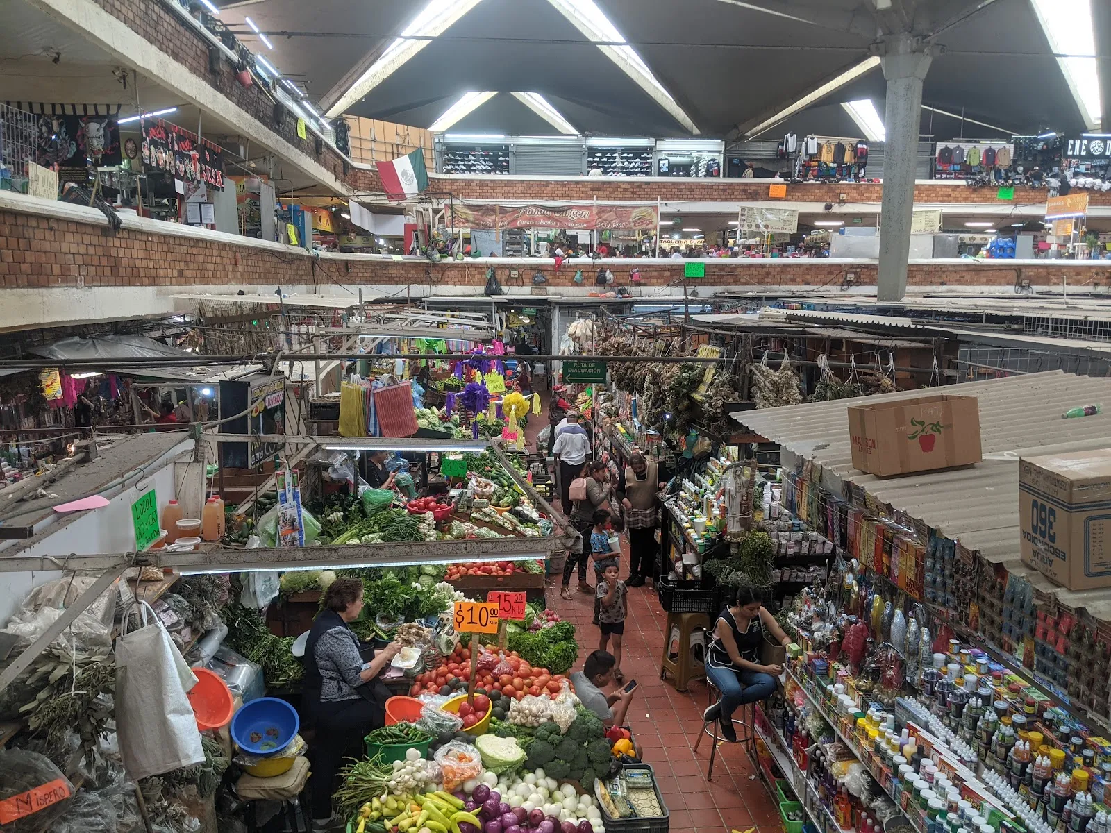
Mercado Libertad, known locally as Mercado San Juan de Dios, is a covered market on Calle Dionisio Rodríguez in Guadalajara, just south of the Hospicio Cabañas. It opened in 1958 and has three floors with close to 3,000 stalls. Leather goods, sandals, sweets, football jerseys, fruit, spices and household items fill the aisles, and a large food section serves torta ahogada, birria and pozole. The layout is a maze, so plan several hours. The Plaza de los Mariachis is right outside.

Name, architect and opening in 1958
Mercado Libertad - San Juan de Dios

The market is officially Mercado Libertad. Most people in Guadalajara call it Mercado San Juan de Dios, after the barrio and the church of the same name. It stands just south of the Hospicio Cabañas, a short walk from the historic center.

The architect was Alejandro Zohn, and the market was inaugurated on 30 December 1958. It replaced an older market on the site. The design relies on bold lines and a practical layout, planned to hold a very large number of stalls and the daily traffic of buyers and sellers.

Today the building has three floors and close to 3,000 stands and stalls. It is open every day and works as a working neighborhood market as much as a sight, so locals shop here alongside visitors.

What is sold inside
Mercado Libertad - San Juan de Dios

The range is wide. Stalls sell fresh fruit and vegetables, seafood, spices, candies, fabric, jewelry, toys, household goods and clothing. There are leather sandals, belts, shoes and phone cases, guitars, and football jerseys that can be made with a custom name. Services are here too, including lottery sales and money exchange. You may also see live chickens for sale.

The largest part of the market is general retail, and some stalls sell imitation branded goods. Many souvenir stalls carry the same items, so a walk through before buying saves time and money.

For handmade work, the artisan towns of Tlaquepaque and Tonalá, just outside Guadalajara, are better sources. Their workshops make silver jewelry, glassware, copper pieces and ceramics. The Tonalá street market runs on Thursdays and Sundays.

Bargaining is usual here, as long as it stays polite. Prices in most other Guadalajara shops are fixed, so this is the place to practice.

Eating in the market

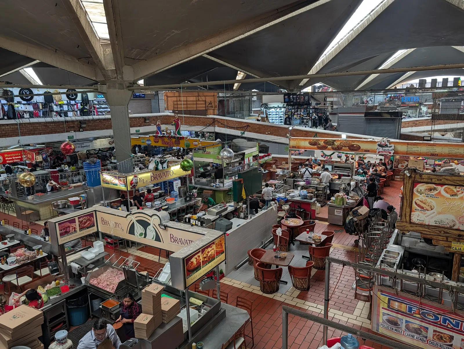
The food section is big enough to take up a visit by itself. Stalls and small counters sell regional dishes, and there are even sushi and ramen stands. A simple way to choose is to watch where local customers are sitting and take a stool there.

The local dish to try is torta ahogada. It is a bread roll filled with fried pork and covered in a tomato and chile sauce. It comes with avocado, onion and radish. The sauce is often made with chiles de árbol, and the sandwich is traditionally eaten with a spoon. Some versions are very hot, and many stalls put extra hot sauce on the side.

Other dishes to look for are birria, a slow-cooked goat or lamb in a tomato broth with tortillas and salsa, and pozole, a pork or chicken stew with corn. Fish ceviche is made with whatever is fresh that day and served on tostadas. Breakfast stalls serve eggs with beans, white cheese and tortillas. Tacos al pastor, barbacoa and carnitas are common, and the market is the one place in the city to find the torta loca.

To drink, try tejuino, a chilled fermented corn drink served with lime and salt. Fresh juices are sold at stalls throughout.

Getting around and planning the visit

The aisles are tightly packed and the layout is a maze, so allow enough time and ask a vendor if you are looking for something specific. Staff and vendors are generally helpful when asked.

Getting to the market by car can be slow, particularly at weekends. There is a paid parking lot. The entrance, a restroom and the parking area are wheelchair accessible. Card and mobile payments are accepted at the market, though the restrooms charge a small fee in coins.

The Plaza de los Mariachis is right outside, and the Hospicio Cabañas is close by, so many visitors combine the three.

Guided street food walks pass through the market and stop at several stalls. They explain the history of the market and the origin of each dish, which helps if the number of stalls feels overwhelming.

Häufige Fragen

How long do you need at Mercado Libertad?

Plan two to four hours. The market has three floors and a maze-like layout, and the food section can take up much of the visit.

What should you eat at Mercado San Juan de Dios?

Start with torta ahogada, the Guadalajara sandwich in spicy sauce. Birria, pozole, tacos al pastor and tejuino, a fermented corn drink, are also common.

Is Mercado Libertad the same as Mercado San Juan de Dios?

Yes. Mercado Libertad is the official name, and San Juan de Dios is the name locals use, after the barrio where it stands.

Can you bargain at the market?

Polite bargaining is expected at many stalls. Most shops elsewhere in Guadalajara have fixed prices.

Is the market wheelchair accessible?

The entrance, a restroom and the parking lot are wheelchair accessible. The aisles are crowded, so the market is easier to navigate on a weekday.

When did Mercado Libertad open?

It was inaugurated on 30 December 1958. Alejandro Zohn designed it to replace an older market.

Weitere Highlights in Guadalajara

Alle entdecken