Pianifica un viaggio
Lingua: Italiano
Pianificatore di viaggiPianifica il tuo viaggio su una mappa

Le migliori destinazioni

EnglishDeutschFrançaisEspañolPortuguêsPortuguês (BR)Italiano
Avviso di viaggio · MessicoAcapulco si trova in o vicino a un'area per cui i governi sconsigliano ogni viaggio: Guerrero.Le indicazioni dipendono dal tuo passaporto. Leggi quelle del tuo governo prima di prenotare.Indicazioni ufficiali
Aree con avvisi
  • Colima · evitare ogni viaggio · Canada, Germania, Francia, Regno Unito
  • Guerrero · evitare ogni viaggio · Canada, Germania, Spagna, Francia, Nuova Zelanda, Regno Unito
  • Sinaloa · evitare ogni viaggio · Canada, Germania, Spagna, Francia, Nuova Zelanda, Regno Unito
  • Chiapas · evitare i viaggi non essenziali · Canada, Spagna, Francia
  • Chihuahua · evitare i viaggi non essenziali · Canada, Francia, Regno Unito
  • Strada federale 199 San Cristóbal de las Casas–Palenque · evitare i viaggi non essenziali · Francia, Regno Unito
  • Guanajuato, a sud delle strade 43D e 45D · evitare i viaggi non essenziali · Canada, Nuova Zelanda
  • Regione di confine con il Guatemala, Chiapas · evitare i viaggi non essenziali · Germania, Francia, Nuova Zelanda
  • Parco nazionale Lagunas de Zempoala · evitare i viaggi non essenziali · Canada, Nuova Zelanda
  • Michoacán · evitare i viaggi non essenziali · Canada, Germania, Nuova Zelanda, Regno Unito
  • Nayarit, entro 20 km dal confine con Sinaloa e Durango · evitare i viaggi non essenziali · Canada, Nuova Zelanda
  • Nuevo León, eccetto Monterrey · evitare i viaggi non essenziali · Canada, Nuova Zelanda
  • Piedras Negras · evitare i viaggi non essenziali · Spagna, Francia
  • Strada 85 Monterrey–Nuevo Laredo · evitare i viaggi non essenziali · Spagna, Francia
  • Sonora · evitare i viaggi non essenziali · Canada, Nuova Zelanda
  • Tamaulipas · evitare i viaggi non essenziali · Canada, Francia, Regno Unito
  • Tecate · evitare i viaggi non essenziali · Francia, Regno Unito
  • Tijuana · evitare i viaggi non essenziali · Francia, Regno Unito
  • Regione di confine con gli Stati Uniti · evitare i viaggi non essenziali · Germania, Spagna, Francia
  • Zacatecas · evitare i viaggi non essenziali · Canada, Germania, Spagna, Francia, Regno Unito

Segnalata anche da un solo governo: Triangolo Celaya–Irapuato–Salamanca, Guanajuato (Francia), Culiacán e dintorni (Francia), A nord di Ciudad Victoria, Tamaulipas (Germania), Strada 129 Martínez de la Torre–Teziutlán (Francia), Strada 131 Tapacoyan–Perote (Francia), Strade secondarie della 180 Martínez de la Torre–Papantla (Francia), Strada 40 Monterrey–Reynosa (Francia), Sud del Michoacán, da Uruapan alla costa (Francia), Acapulco (Francia), Bassa California, eccetto Tijuana e Tecate (Francia), Ciudad Acuña (Spagna), Ciudad Juárez e dintorni (Spagna), Ciudad Obregón (Francia), Coahuila, eccetto il sud (Nuova Zelanda), Coatzacoalcos (Francia), Quartieri a nord e nord-est dello Zócalo, Città del Messico (Francia), Durango (Francia), Est del Nuevo León, al confine con Tamaulipas (Francia), Guanajuato (Spagna), Guanajuato, strada statale 45 tra León e Irapuato (Nuova Zelanda), Guanajuato, a sud-ovest della strada 45D (Regno Unito), Jalisco, entro 50 km dal confine con il Michoacán (Canada), Monclova (Spagna), Morelos (Francia), Nayarit (Francia), Nogales (Francia), Zone rurali non turistiche della Baja California (Spagna), Zone rurali non turistiche di Chihuahua (Spagna), Zone rurali non turistiche di Coahuila (Spagna), Zone rurali non turistiche di Durango (Spagna), Zone rurali non turistiche di Sonora (Spagna), Comuni del nord di Jalisco (Regno Unito), Tamaulipas settentrionale, da San Fernando al confine con gli USA (Spagna), Veracruz settentrionale, al confine con il Tamaulipas (Spagna), Veracruz settentrionale da Martínez de la Torre (Francia), Strada 150D, Puebla–Orizaba (Francia), Strada 190, Oaxaca–Santo Domingo Tehuantepec (Francia), Strade 85 e 83 Monterrey–Ciudad Victoria–Tampico (Francia), Strada 95 Città del Messico–Cuernavaca (Francia), Selva Lacandona (Francia), Sud e sud-ovest del lago di Chapala, Jalisco (Regno Unito), Sud-ovest del Jalisco e Los Altos, eccetto Puerto Vallarta (Francia), Sud-ovest del Michoacán (Francia), Sud-ovest del Tamaulipas (Francia), Sud dello stato di Guanajuato (Francia), Sud del Michoacán, a sud di Morelia (Spagna), Fascia entro 40 km dal confine con il Guatemala, Chiapas (Regno Unito), Tepic (Nuova Zelanda), Toluca (Francia), Città di Veracruz (Francia)

GovernoConsigliAggiornatoLeggi le indicazioni
Regno Unito (FCDO)No advice against the whole country (regional advisories)–Leggi le indicazioni
Stati Uniti (Dipartimento di Stato)Exercise increased caution29 mag 2026Leggi le indicazioni
Canada (Affari globali)Exercise a high degree of caution (regional advisories)–Leggi le indicazioni
Germania (Auswärtiges Amt)Besondere Vorsicht walten lassen (Sicherheitslage) (regional advisories)19 ott 2026Leggi le indicazioni
Nuova Zelanda (SafeTravel)Exercise increased caution (regional advisories)–Leggi le indicazioni
Francia (Ministero per l'Europa e gli Affari esteri)Vigilance renforcée pour le reste du pays (regional advisories)–Leggi le indicazioni

Verificato ogni giorno dalle indicazioni pubblicate dai governi; ultima verifica 2 nov 2026.RoamLedger riassume le indicazioni ufficiali; non è un consiglio di alcun governo.

La Quebrada
Luogo simbolo

La Quebrada

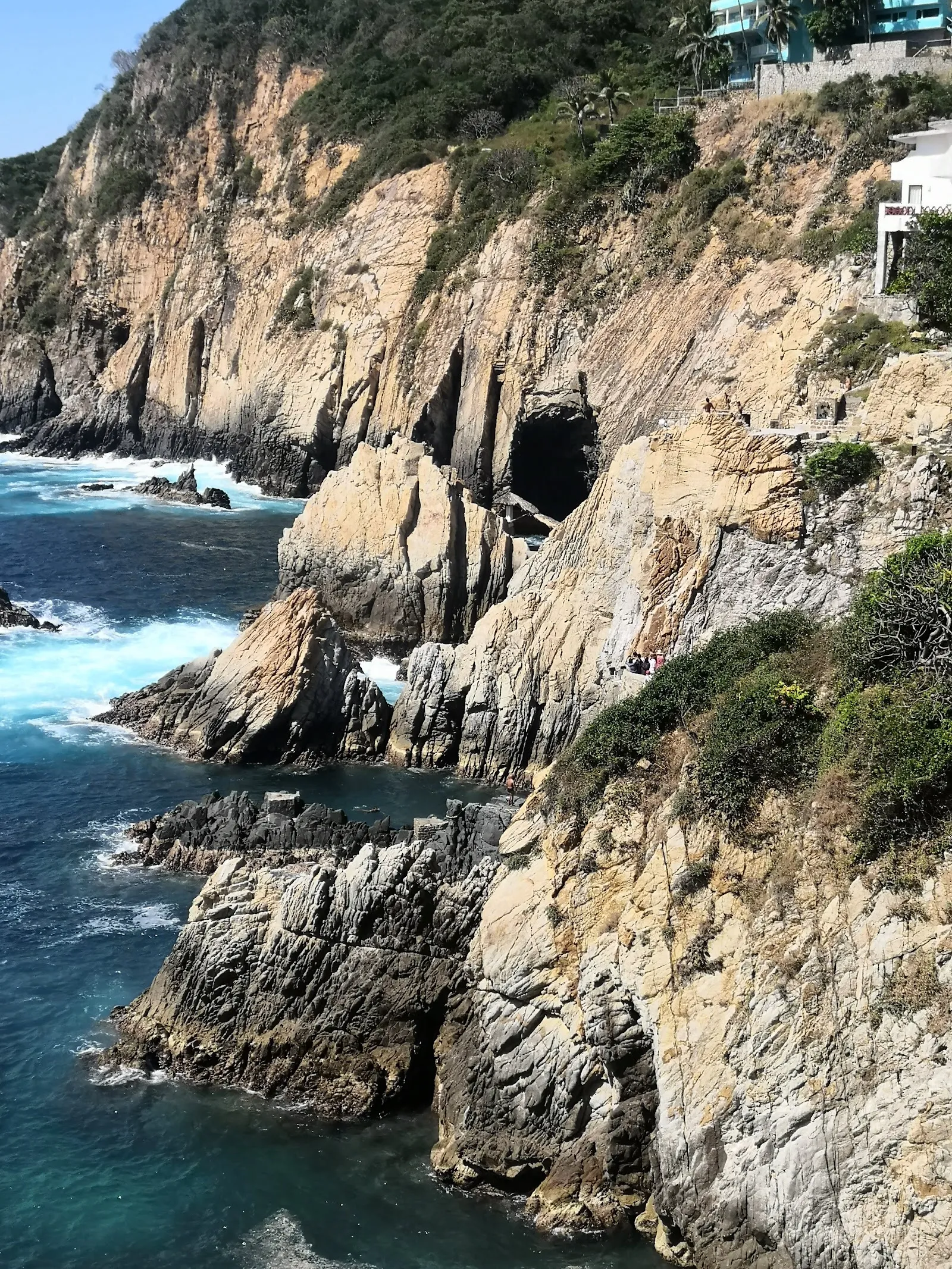
La Quebrada is a ravine on Avenida Adolfo López Mateos in Las Playas, Acapulco, where cliff divers perform daily shows for the public.

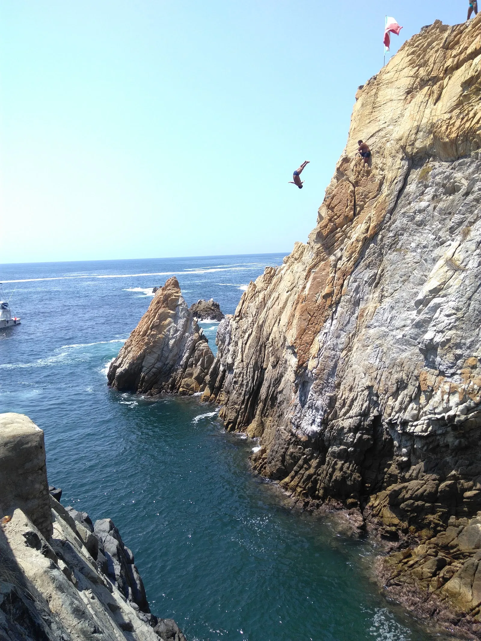
La Quebrada is a ravine on Avenida Adolfo López Mateos in Las Playas, Acapulco, where cliff divers perform daily shows for the public. Divers have worked here since the 1930s. They jump from about 35 meters (130 feet) into the narrow sea channel below, and each one waits for an incoming wave so the water is deep enough for a safe landing. Viewing platforms sit close to the cliff face, so you see the leap, the splash and the climb back out. A small shrine stands near the jump point, and a restaurant sits on one of the cliffs.

How a dive is timed
La Quebrada
La Quebrada

La Quebrada means "ravine" in Spanish, and the name describes the site. Two cliffs face each other across a narrow channel of sea. The divers jump from heights of about 35 meters, roughly 130 feet, and the water below is only deep enough at the right moment.

That moment comes with the waves. Waves break on the rocks a short way offshore, and the divers watch them, together with a wind flag nearby, to judge when the water will be at its peak. A diver who jumps too early or too late risks serious injury, so you will often see a pause before the leap. Nothing in that pause is for show. It is the part of the dive that keeps the diver safe.

Swimming across and climbing up
La Quebrada
La Quebrada

Divers do not simply walk to the edge. Before a dive, they enter the water across from the jump point, swim over and climb the cliff by hand to reach the launch spot. You can follow this from the viewing areas, so the show begins before anyone leaves the rock.

Diving here is often a family matter. A visitor from a cruise-ship tour learned that the team is close to a family business, and that a 13-year-old girl was getting ready for her first year with the divers. Near the jump point there is a small shrine, and each diver has the chance to visit it before jumping. It is a quiet detail beside a loud spectacle, and a polite audience stays still and watches it with respect.

A long history on the ravine

La Quebrada has been one of Acapulco's best-known attractions since the 1930s. Divers have performed here across the decades, and the shows are now held daily for the public.

The ravine also draws other activities. A restaurant sits on one of the cliffs, so you can eat while watching divers jump. A zipline starts from the top of one of the cliffs and looks out over the ocean and the city. Some organized tours combine the dive show with lunch and drinks, and cruise-ship excursions stop here as well.

Planning the visit

The site is at Avenida Adolfo López Mateos 75, in the Las Playas area. There is an entry fee to watch the show. Visitors have reported around 100 pesos per person, and the gate has been reported to open about 30 minutes before the dive. Confirm both on the day.

The approach involves steps, and the best views from the lower platforms need more of them. Crowds gather for each show, so arrive early if you want a spot close to the edge. The sun is strong and there is little shade for waiting, so a hat and water make the visit more comfortable. Parking is free, and there are restrooms on site.

FAQ

Is there an entry fee at La Quebrada?

Yes. Visitors have reported about 100 pesos per person, and one paid around five US dollars. Check the current price before you go.

How high do the La Quebrada divers jump?

They jump from about 35 meters, which is roughly 130 feet. Each diver times the jump to the waves so the water below is deep enough.

Where is La Quebrada?

It is at Avenida Adolfo López Mateos 75, in the Las Playas area of Acapulco de Juárez, Guerrero.

Are there many steps to the viewing areas?

Yes, the best viewing spots involve several steps. The show can also be seen from higher up, though from farther away.

Can you eat near La Quebrada?

Yes. A restaurant sits on one of the cliffs, and the historic El Mirador hotel is a lunch option after the show.
Altre attrazioni imperdibili a Acapulco

Esplora tutto