Reise planen
Sprache: Deutsch
ReiseplanerPlane deine Reise auf einer Karte

Top-Reiseziele

EnglishDeutschFrançaisEspañolPortuguêsPortuguês (BR)Italiano
Reisehinweis · MexikoMonterrey liegt in oder nahe einem Gebiet, für das Regierungen von allen außer unbedingt notwendigen Reisen abraten: Route 85 Monterrey–Nuevo Laredo.Die Empfehlung hängt von Ihrem Reisepass ab. Lesen Sie vor der Buchung die Hinweise Ihrer eigenen Regierung.Offizielle Hinweise
Gebiete mit Warnungen
  • Colima · alle Reisen vermeiden · Kanada, Deutschland, Frankreich, Vereinigtes Königreich
  • Guerrero · alle Reisen vermeiden · Kanada, Deutschland, Spanien, Frankreich, Neuseeland, Vereinigtes Königreich
  • Sinaloa · alle Reisen vermeiden · Kanada, Deutschland, Spanien, Frankreich, Neuseeland, Vereinigtes Königreich
  • Chiapas · nicht notwendige Reisen vermeiden · Kanada, Spanien, Frankreich
  • Chihuahua · nicht notwendige Reisen vermeiden · Kanada, Frankreich, Vereinigtes Königreich
  • Bundesstraße 199 San Cristóbal de las Casas–Palenque · nicht notwendige Reisen vermeiden · Frankreich, Vereinigtes Königreich
  • Guanajuato, südlich der Schnellstraßen 43D und 45D · nicht notwendige Reisen vermeiden · Kanada, Neuseeland
  • Grenzgebiet zu Guatemala, Chiapas · nicht notwendige Reisen vermeiden · Deutschland, Frankreich, Neuseeland
  • Nationalpark Lagunas de Zempoala · nicht notwendige Reisen vermeiden · Kanada, Neuseeland
  • Michoacán · nicht notwendige Reisen vermeiden · Kanada, Deutschland, Neuseeland, Vereinigtes Königreich
  • Nayarit, innerhalb von 20 km zur Grenze zu Sinaloa und Durango · nicht notwendige Reisen vermeiden · Kanada, Neuseeland
  • Nuevo León, außer Monterrey · nicht notwendige Reisen vermeiden · Kanada, Neuseeland
  • Piedras Negras · nicht notwendige Reisen vermeiden · Spanien, Frankreich
  • Route 85 Monterrey–Nuevo Laredo · nicht notwendige Reisen vermeiden · Spanien, Frankreich
  • Sonora · nicht notwendige Reisen vermeiden · Kanada, Neuseeland
  • Tamaulipas · nicht notwendige Reisen vermeiden · Kanada, Frankreich, Vereinigtes Königreich
  • Tecate · nicht notwendige Reisen vermeiden · Frankreich, Vereinigtes Königreich
  • Tijuana · nicht notwendige Reisen vermeiden · Frankreich, Vereinigtes Königreich
  • Grenzregion zu den USA · nicht notwendige Reisen vermeiden · Deutschland, Spanien, Frankreich
  • Zacatecas · nicht notwendige Reisen vermeiden · Kanada, Deutschland, Spanien, Frankreich, Vereinigtes Königreich

Außerdem von einer Regierung genannt: Dreieck Celaya–Irapuato–Salamanca, Guanajuato (Frankreich), Culiacán und Umgebung (Frankreich), Norden von Ciudad Victoria, Tamaulipas (Deutschland), Straße 129 Martínez de la Torre–Teziutlán (Frankreich), Straße 131 Tapacoyan–Perote (Frankreich), Nebenstraßen der 180 Martínez de la Torre–Papantla (Frankreich), Straße 40 Monterrey–Reynosa (Frankreich), Süden von Michoacán, von Uruapan bis zur Küste (Frankreich), Acapulco (Frankreich), Baja California, außer Tijuana und Tecate (Frankreich), Ciudad Acuña (Spanien), Ciudad Juárez und Umgebung (Spanien), Ciudad Obregón (Frankreich), Coahuila, außer dem Süden (Neuseeland), Coatzacoalcos (Frankreich), Viertel nördlich und nordöstlich des Zócalo, Mexiko-Stadt (Frankreich), Durango (Frankreich), Osten von Nuevo León, an Tamaulipas grenzend (Frankreich), Guanajuato (Spanien), Guanajuato, Schnellstraße 45 zwischen León und Irapuato (Neuseeland), Guanajuato, südwestlich der Schnellstraße 45D (Vereinigtes Königreich), Jalisco, innerhalb von 50 km zur Grenze zu Michoacán (Kanada), Monclova (Spanien), Morelos (Frankreich), Nayarit (Frankreich), Nogales (Frankreich), Abgelegene ländliche Gebiete von Baja California (Spanien), Abgelegene ländliche Gebiete von Chihuahua (Spanien), Abgelegene ländliche Gebiete von Coahuila (Spanien), Abgelegene ländliche Gebiete von Durango (Spanien), Abgelegene ländliche Gebiete von Sonora (Spanien), Nördliche Gemeinden von Jalisco (Vereinigtes Königreich), Nördliches Tamaulipas, von San Fernando bis zur US-Grenze (Spanien), Nördliches Veracruz an der Grenze zu Tamaulipas (Spanien), Nördliches Veracruz ab Martínez de la Torre (Frankreich), Straße 150D, Puebla–Orizaba (Frankreich), Straße 190, Oaxaca–Santo Domingo Tehuantepec (Frankreich), Route 85 und 83 Monterrey–Ciudad Victoria–Tampico (Frankreich), Route 95 Mexiko-Stadt–Cuernavaca (Frankreich), Selva Lacandona (Frankreich), Süden und Südwesten des Chapala-Sees, Jalisco (Vereinigtes Königreich), Südwesten Jaliscos und Los Altos, außer Puerto Vallarta (Frankreich), Südwesten von Michoacán (Frankreich), Südwesten von Tamaulipas (Frankreich), Süden des Bundesstaates Guanajuato (Frankreich), Süden von Michoacán, südlich von Morelia (Spanien), Streifen bis 40 km von der guatemaltekischen Grenze, Chiapas (Vereinigtes Königreich), Tepic (Neuseeland), Toluca (Frankreich), Stadt Veracruz (Frankreich)

RegierungHinweiseAktualisiertHinweise lesen
Vereinigtes Königreich (FCDO)No advice against the whole country (regional advisories)–Hinweise lesen
Vereinigte Staaten (State Dept)Exercise increased caution29. Mai 2026Hinweise lesen
Kanada (Global Affairs)Exercise a high degree of caution (regional advisories)–Hinweise lesen
Deutschland (Auswärtiges Amt)Besondere Vorsicht walten lassen (Sicherheitslage) (regional advisories)19. Okt. 2026Hinweise lesen
Neuseeland (SafeTravel)Exercise increased caution (regional advisories)–Hinweise lesen
Frankreich (Ministerium für Europa und Auswärtige Angelegenheiten)Vigilance renforcée pour le reste du pays (regional advisories)–Hinweise lesen

Täglich anhand der veröffentlichten Hinweise der Regierungen geprüft; zuletzt geprüft am 3. Nov. 2026.RoamLedger fasst offizielle Hinweise zusammen; es handelt sich nicht um Empfehlungen einer Regierung.

La Huasteca
Park

La Huasteca

La Huasteca is a park in the Cumbres de Monterrey National Park, about 20 minutes from downtown Monterrey, in the Santa Catarina area.

La Huasteca is a park in the Cumbres de Monterrey National Park, about 20 minutes from downtown Monterrey, in the Santa Catarina area. Pale limestone peaks rise on both sides of a canyon, and the trails and climbing routes run through the rock. Visitors come to hike, bike, run, climb and rappel, and to look over the city and the mountains from the high points. Wildlife and plants found only in this region are here too. Go early in the day, bring water, and plan your food before you arrive.

A limestone canyon above the city
La Huasteca
La Huasteca

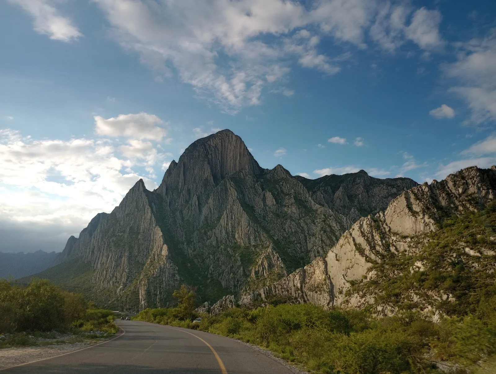
La Huasteca sits inside the Cumbres de Monterrey National Park, south of the city in the Santa Catarina area. Its limestone mountains rise on either side of the canyon in tall, thin ridges that look almost like blades. The rock is pale, and in many places there is little green on the faces, so the walls look different as the light moves across them.

The dry bed of the Santa Catarina River runs through the landscape, and the rock formations along it are among the most photographed parts of the park. In the rainy season, the water that forms between the rocks is used for kayaking.

Climbing, rappelling and the caves
La Huasteca
La Huasteca

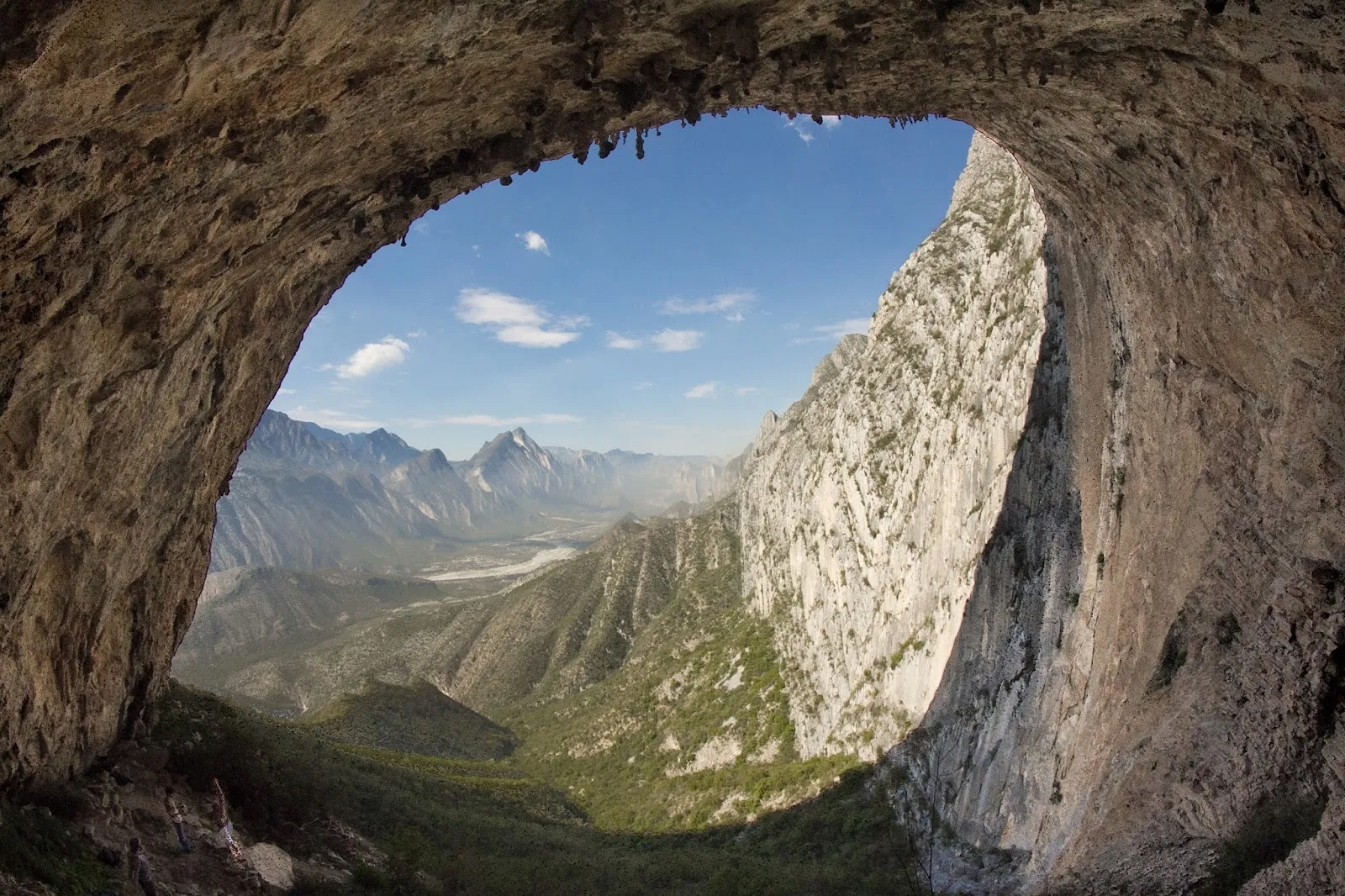
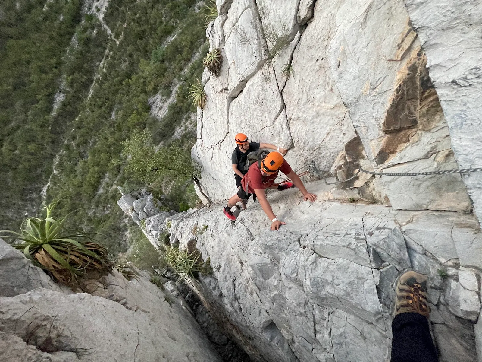
La Huasteca is one of the first climbing areas established near Monterrey. Its rock formations, some reaching about 120 meters, suit both climbing and rappelling. Permits may be required for these activities, so confirm the rules before you go.

Two caves are open to visitors: Cueva de los Murciélagos, the Cave of the Bats, and Cueva de la Virgen, the Cave of the Virgin. Both shelter wildlife and rare plant species. A professional guide is recommended for the trip inside, so follow the guide's instructions and move carefully on the rock.

Wildlife and plants

The park is home to endemic species, including the agave Agave victoria-reginae and the pine Pinus santa catarinae. Eagles and condors are the birds most often mentioned by visitors, and the park also has lizards, foxes, armadillos, bats, snakes and scorpions. Look before you put your hands on ledges or step into shaded rock gaps, and do not disturb the animals or plants you find.

Getting there and moving around

The entrance is gated, and entry to the park is free. Guided tours may cost extra. The park is about 20 minutes from downtown Monterrey by car. It is also possible to walk in from Santa Catarina town.

The main road inside the park is good for cycling and an easy drive. For longer trails, many people ride further in, where more trails leave the road. A bike rental has been available inside the park, but check whether it is running during your visit.

A few stands along the road sell drinks and snacks. Good food is available just inside the canyon, and there is little after that point. The park has picnic tables, a barbecue grill, public restrooms, a playground and a skateboarding area, so a picnic is simple to plan. Dogs are allowed, and debit and credit cards are accepted.

Häufige Fragen

Is there an entry fee?

The entrance is free. Guided tours may cost extra, so ask the price before you start.

Do you need a guide for the caves?

A professional guide is recommended for Cueva de los Murciélagos and Cueva de la Virgen, which are the two caves open to visitors.

Can you rent a bike inside the park?

A bike rental has been available inside the park. Check whether it is open during your visit, since seasonal availability is unclear.

Is there food inside La Huasteca?

Good food is available just inside the canyon, with little after that. Pack water and snacks for longer walks.

Can you walk to La Huasteca from Santa Catarina?

Yes, it is possible to walk in from Santa Catarina town.

Weitere Highlights in Monterrey

Alle entdecken