Reise planen
Sprache: Deutsch
ReiseplanerPlane deine Reise auf einer Karte

Top-Reiseziele

EnglishDeutschFrançaisEspañolPortuguêsPortuguês (BR)Italiano
Reisehinweis · KolumbienEinige Regierungen raten von Reisen in Teile von Kolumbien ab.Die Warnungen gelten nur für diese Gebiete: Departement Arauca, Stadt Buenaventura, Departement Caquetá, Region Catatumbo, Departement Cauca, Departement Chocó, Grenzgebiete Kolumbien–Venezuela, Grenzgebiete zu Ecuador, Departement Norte de Santander, Tumaco, Departamento Valle del Cauca, Departamento Casanare, Departamento Guainía, Departamento Guaviare, Departamento Meta, Departamento Nariño, Nord-Antioquia, Departement Putumayo, Südliches Bolívar, Südliches Córdoba, Departamento Vaupés, Departement Vichada.Die Empfehlung hängt von Ihrem Reisepass ab. Lesen Sie vor der Buchung die Hinweise Ihrer eigenen Regierung.Offizielle Hinweise
Gebiete mit Warnungen
  • Departement Arauca · alle Reisen vermeiden · Kanada, Spanien, Neuseeland, Vereinigtes Königreich, USA
  • Stadt Buenaventura · alle Reisen vermeiden · Kanada, Neuseeland
  • Departement Caquetá · alle Reisen vermeiden · Kanada, Spanien, Frankreich, Neuseeland
  • Region Catatumbo · alle Reisen vermeiden · Spanien, Neuseeland
  • Departement Cauca · alle Reisen vermeiden · Kanada, Deutschland, Spanien, Italien, Neuseeland, Vereinigtes Königreich, USA
  • Departement Chocó · alle Reisen vermeiden · Kanada, Deutschland, Spanien, Neuseeland, Vereinigtes Königreich
  • Grenzgebiete Kolumbien–Venezuela · alle Reisen vermeiden · Deutschland, Frankreich, Neuseeland
  • Grenzgebiete zu Ecuador · alle Reisen vermeiden · Frankreich, Neuseeland
  • Departement Norte de Santander · alle Reisen vermeiden · Kanada, Deutschland, Neuseeland, Vereinigtes Königreich, USA
  • Tumaco · alle Reisen vermeiden · Kanada, Neuseeland
  • Departamento Valle del Cauca · alle Reisen vermeiden · Kanada, Deutschland, Italien, Neuseeland, USA
  • Departamento Casanare · nicht notwendige Reisen vermeiden · Spanien, Neuseeland
  • Departamento Guainía · nicht notwendige Reisen vermeiden · Kanada, Frankreich, Neuseeland
  • Departamento Guaviare · nicht notwendige Reisen vermeiden · Kanada, Deutschland, Spanien, Frankreich, Neuseeland, Vereinigtes Königreich
  • Departamento Meta · nicht notwendige Reisen vermeiden · Kanada, Deutschland, Spanien, Neuseeland
  • Departamento Nariño · nicht notwendige Reisen vermeiden · Kanada, Deutschland, Spanien, Frankreich, Neuseeland
  • Nord-Antioquia · nicht notwendige Reisen vermeiden · Deutschland, Frankreich
  • Departement Putumayo · nicht notwendige Reisen vermeiden · Kanada, Deutschland, Spanien, Frankreich, Neuseeland
  • Südliches Bolívar · nicht notwendige Reisen vermeiden · Deutschland, Frankreich, Neuseeland, Vereinigtes Königreich
  • Südliches Córdoba · nicht notwendige Reisen vermeiden · Deutschland, Frankreich, Neuseeland, Vereinigtes Königreich
  • Departamento Vaupés · nicht notwendige Reisen vermeiden · Kanada, Frankreich
  • Departement Vichada · nicht notwendige Reisen vermeiden · Kanada, Frankreich, Neuseeland

Außerdem von einer Regierung genannt: Grenzgebiete zu Brasilien (Frankreich), Straße Cali–Popayán–Pasto–Ipiales (Frankreich), Ufer des Río Cauca (Sucre, Córdoba, Bolívar und Nord-Antioquia) (Frankreich), Grenze Kolumbien–Venezuela, innerhalb von 10 km (USA), Grenze Kolumbien–Venezuela, innerhalb von 50 km (ohne Cúcuta) (Kanada), Gemeinden unmittelbar südlich von Cali (Frankreich), Darién-Lücke im Chocó (Neuseeland), Grenze zu Ecuador, innerhalb von 50 km (ohne Grenzübergang Ipiales) (Kanada), Gemeinden González und Río de Oro (Cesar) (Kanada), Montes de María (Spanien), Nordwestzone um die Grenze zu Panama und den Golf von Urabá (Spanien), Pazifikküste (Chocó, Cauca, Valle del Cauca), ohne Nuquí und Bahía Solano (Frankreich), Grenzgebiete zu Panama (Frankreich), Grenze zu Panama, innerhalb von 100 km (Kanada), Grenzgebiete zu Peru (Frankreich), Departamento Amazonas (Frankreich), Amazonas, im Umkreis von 20 km zur peruanischen Grenze westlich von Puerto Nariño (Kanada), Departamento Antioquia (Neuseeland), Region Ariari im Süden von Meta (Vereinigtes Königreich), Bahía Solano, Capurganá und Nuquí (Kanada), Region Bajo Cauca (Antioquia) (Vereinigtes Königreich), Cartagena del Chairá (Vereinigtes Königreich), Grenze zu Venezuela, 5 km (übrige Grenze) (Vereinigtes Königreich), Stadt Cúcuta (Kanada), Erdbebengebiet (Eje Cafetero und Suroriente) (Spanien), Östliches Valle del Cauca (Frankreich), Grenze zu Ecuador, 5 km (Vereinigtes Königreich), Stadt Florencia (Kanada), Hanglagen-Comunas von Medellín (Frankreich), Stadt Ipiales und Grenzübergang (Kanada), Gemeinde Jamundí (Valle del Cauca) (Vereinigtes Königreich), La Montañita (Vereinigtes Königreich), Nordwest-Antioquia, nördlich von Buriticá und westlich der Straße 62 (Kanada), Orito (Vereinigtes Königreich), Nationalpark Paramillo (Córdoba) (Kanada), Paujil (Vereinigtes Königreich), Stadt Popayán (Kanada), Volkstümliche Viertel im Süden Bogotás (Kennedy, Ciudad Bolívar, Altos, Cazucá, Soacha) (Frankreich), Puerto Asís (Vereinigtes Königreich), Puerto Caicedo (Vereinigtes Königreich), Gemeinde Puerto Carreño (Vichada) (Vereinigtes Königreich), Puerto Guzmán (Vereinigtes Königreich), Puerto Leguízamo (Vereinigtes Königreich), Puerto Rico (Caquetá) (Vereinigtes Königreich), Stadt Quibdó (Frankreich), Die Unterregionen San Jorge und La Mojana in Sucre (Neuseeland), San Miguel (Putumayo) (Vereinigtes Königreich), San Vicente del Caguán (Vereinigtes Königreich), Region Sanquianga (Nariño) (Vereinigtes Königreich), Departement Santander (Frankreich), Südpazifische Region (Nariño) (Vereinigtes Königreich), Südliches Sucre (Frankreich), Südliches Tolima (Deutschland), Subregion Sur (Cesar) (Neuseeland), Region Telembí (Nariño) (Vereinigtes Königreich), Region Urabá (Antioquia) (Vereinigtes Königreich), Valle del Guamuez (Vereinigtes Königreich), Westliches Valle del Cauca, einschließlich Buenaventura (Vereinigtes Königreich)

RegierungHinweiseAktualisiertHinweise lesen
Vereinigtes Königreich (FCDO)No advice against the whole country (regional advisories)–Hinweise lesen
Vereinigte Staaten (State Dept)Reconsider travel31. März 2026Hinweise lesen
Kanada (Global Affairs)Exercise a high degree of caution (regional advisories)–Hinweise lesen
Deutschland (Auswärtiges Amt)Keine Reisewarnung für das ganze Land (regional advisories)13. Okt. 2026Hinweise lesen
Neuseeland (SafeTravel)Exercise increased caution due to violent crime and the threat of terrorism (regional advisories)–Hinweise lesen
Frankreich (Ministerium für Europa und Auswärtige Angelegenheiten)Increased vigilance, with specific areas to avoid (regional advisories)–Hinweise lesen

Täglich anhand der veröffentlichten Hinweise der Regierungen geprüft; zuletzt geprüft am 2. Nov. 2026.RoamLedger fasst offizielle Hinweise zusammen; es handelt sich nicht um Empfehlungen einer Regierung.

a group of people standing in front of a church
Kirche

Iglesia de San Antonio

Iglesia de San Antonio is a small whitewashed church on top of San Antonio Hill, west of Cali's historic center.

Iglesia de San Antonio is a small whitewashed church on top of San Antonio Hill, west of Cali's historic center. It was built in 1747 and is dedicated to Saint Anthony of Padua. Inside, you can see 17th-century carved wooden saints in the Quito School style. The church sits in a small park with shade trees and benches, and from the hilltop you get wide views over the city. Come in the early morning for quiet, or in the evening for the street scene around the park.

A church from 1747 on San Antonio Hill
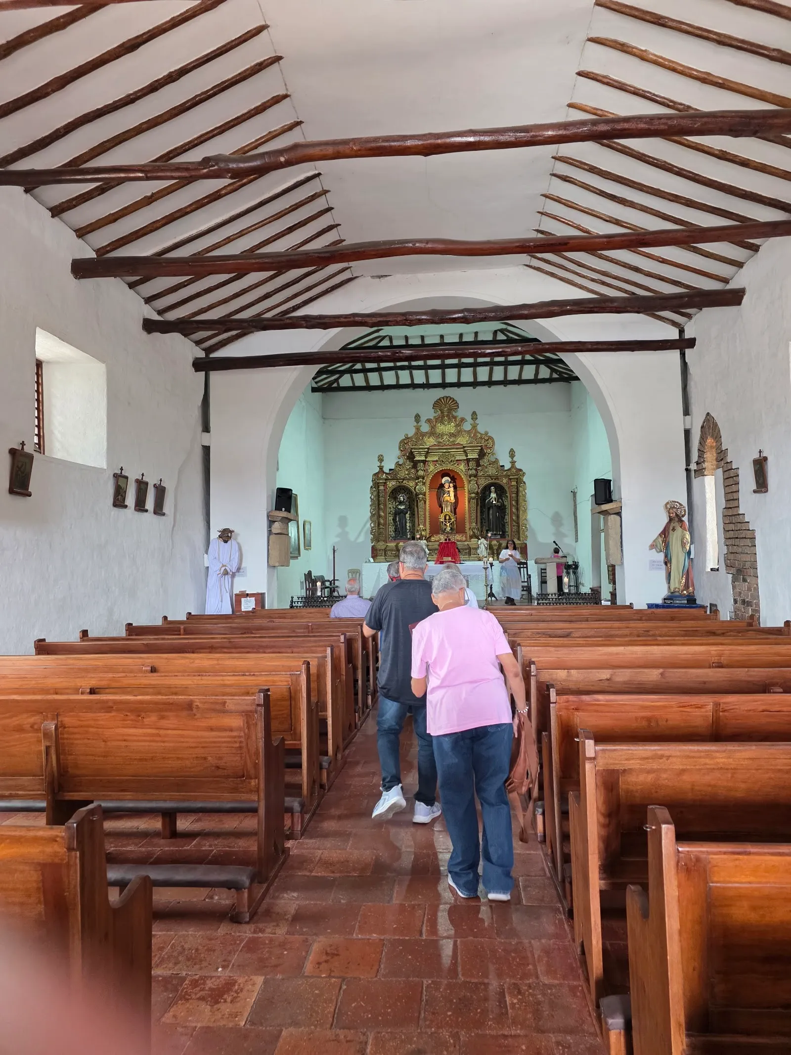
Iglesia de San Antonio

Iglesia de San Antonio was built in 1747, when Cali had fewer than 5,000 inhabitants. It is dedicated to Saint Anthony of Padua and sits on the hill known as Colina de San Antonio, west of the old city center. It is one of the city's colonial buildings, with a simple brick and whitewashed front.

The hill gives the church its setting. The surrounding San Antonio neighborhood mixes old colonial houses with small shops, galleries and restaurants, and its streets are full of color and artwork.

Inside the church
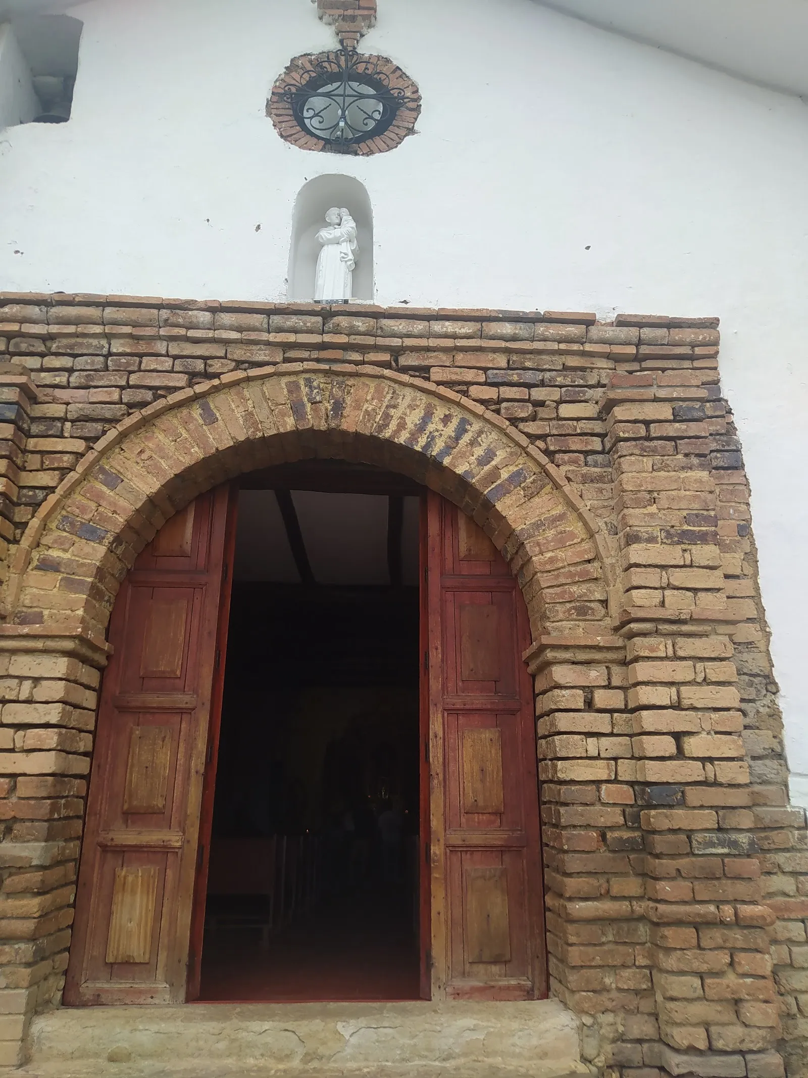
Iglesia de San Antonio

The interior keeps original elements from the 1700s. The main altar is in the Baroque style and carries colonial-era paintings. The most valuable pieces are the tallas quiteñas, carved wooden statues of saints from the 17th century, made in the style of the Quito School. The church is small, so the figures are close enough to study slowly.

Many people come here to pray, and the statue of Saint Anthony is a focus for them. Keep your voice low, give worshippers room, and ask before photographing anyone at prayer.

The park and the view

The church sits in a small park with shade trees, benches and gardens. It is a good spot for birdwatching and for slow mornings. From the top of the hill, the view takes in much of the city. In the early morning, the hill is much quieter than the streets below.

The climb involves many steps, and the hill gets very hot around midday, so plan the walk for morning or late afternoon.

Evenings and weekends

On Thursday, Friday and Saturday, performers, storytellers and vendors gather around the park. Vendors sell snacks, candy, roasted corn, handicrafts and trinkets, so you can buy something as you walk. Weekend nights are the busiest time, when friends meet in the park.

In December, the park is lit with Christmas lights, and the area has activities every evening. Later at night, the area becomes quiet.

Getting there and eating nearby

A paid parking lot is on site, along with a wheelchair accessible parking lot. Shops and restaurants surround the park, which makes the church a good stop for a midday or early evening break.

Parador San Antonio, a short walk down the hill, serves empanadas and ají, a homemade Colombian hot sauce. La Boheme, a tapas bar built into the hillside, is also nearby, with craft beer on the menu.

Häufige Fragen

Is the church open every day?

Yes, it is open every day of the week. Check the page for the current hours before you go.

Is there parking?

Yes. There is a paid parking lot and a wheelchair accessible parking lot.

What is the best time to visit?

Early morning is quiet and suits a relaxed look at the church and the view. Thursday to Saturday evenings bring performers and vendors, and weekend nights are the busiest.

Is it a steep walk up?

The church is at the top of a hill, and the route involves many steps. The area gets very hot around midday, so morning or late afternoon is more comfortable.
Weitere Highlights in Cali

Alle entdecken